
Mappa topografica Doylestown
Mappa interattiva
Clicca sulla mappa per visualizzare l'altitudine.
A proposito di questa mappa
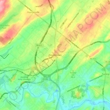
Nome: Mappa topografica Doylestown, altitudine, rilievo.
Luogo: Doylestown, Bucks County, Pennsylvania, 18901, United States (40.27004 -75.17046 40.35004 -75.09046)
Altitudine media: 100 m
Altitudine minima: 51 m
Altitudine massima: 175 m
An electric telegraph station was built in 1846, and the North Pennsylvania Railroad completed a branch to Doylestown in 1856. The first gas lights were introduced in 1854. Because of the town's relatively high elevation and a lack of strong water power, substantial industrial development never occurred and Doylestown evolved to have a professional and residential character.