
Fai una donazione
Equipaggiati per la tua prossima avventura:
In qualità di Affiliato Amazon, questo sito riceve una commissione sugli acquisti idonei, senza costi aggiuntivi per l’utente.
Mappa topografica Oakland
Clicca sulla mappa per visualizzare l'altitudine.
Fai una donazione
Equipaggiati per la tua prossima avventura:
In qualità di Affiliato Amazon, questo sito riceve una commissione sugli acquisti idonei, senza costi aggiuntivi per l’utente.
Oakland
Oakland, like much of Northern California, is susceptible to winter rainstorms and Atmospheric rivers. The wettest "rain year" was from July 1997 to June 1998 with 47.76 inches (1,213.1 mm) and the driest from July 2020 to June 2021 with 8.03 inches (204.0 mm). The most rainfall in one month was 15.35 inches (390 mm) in January 1911. The most rainfall in 24 hours was 4.75 inches (121 mm) on December 31, 2022. Rainfall near the bayfront is only 23 inches (580 mm), but is higher in the Oakland Hills to the east (up to 30 inches [760 mm]), with nearly all precipitation falling between November and April. While measurable amounts of snowfall in Oakland at sea level is very rare, light snow accumulates on the ground the higher elevations of the Oakland hills with more regularity.
Fai una donazione
Equipaggiati per la tua prossima avventura:
In qualità di Affiliato Amazon, questo sito riceve una commissione sugli acquisti idonei, senza costi aggiuntivi per l’utente.
A proposito di questa mappa
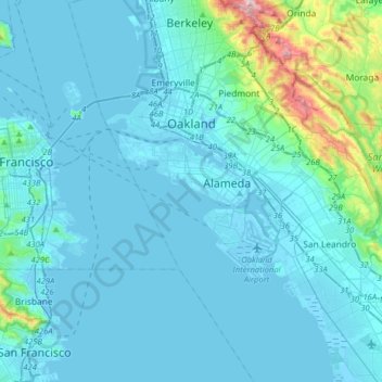
Nome: Mappa topografica Oakland, altitudine, rilievo.
Luogo: Oakland, Alameda County, California, United States (37.63011 -122.35589 37.88543 -122.11442)
Altitudine media: 51 m
Altitudine minima: -11 m
Altitudine massima: 569 m
Fai una donazione
Equipaggiati per la tua prossima avventura:
In qualità di Affiliato Amazon, questo sito riceve una commissione sugli acquisti idonei, senza costi aggiuntivi per l’utente.
Altre mappe topografiche
Clicca su una mappa per visualizzarne la topografia, l'altitudine e il rilievo.
Coyote Hills Regional Park
United States > California > Alameda County > Fremont
Altitudine media: 5 m
Berkeley Hills
United States > California > Alameda County > Berkeley
The Berkeley Hills are bounded by the major Hayward Fault along their western base, and the minor Wildcat fault on their eastern side. The highest peaks are Grizzly Peak with an elevation of 1,754 feet (535 m) and Round Top, an extinct volcano with an elevation of 1,761 feet (537 m) and William Rust Summit at…
Altitudine media: 158 m
Fai una donazione
Equipaggiati per la tua prossima avventura:
In qualità di Affiliato Amazon, questo sito riceve una commissione sugli acquisti idonei, senza costi aggiuntivi per l’utente.
Fai una donazione
Equipaggiati per la tua prossima avventura:
In qualità di Affiliato Amazon, questo sito riceve una commissione sugli acquisti idonei, senza costi aggiuntivi per l’utente.
Berkeley Hills
United States > California > Alameda County > Berkeley
The Berkeley Hills are bounded by the major Hayward Fault along their western base, and the minor Wildcat fault on their eastern side. The highest peaks are Grizzly Peak with an elevation of 1,754 feet (535 m) and Round Top, an extinct volcano with an elevation of 1,761 feet (537 m) and William Rust Summit at…
Altitudine media: 158 m
Drawbridge
United States > California > Alameda County > Fremont
Drawbridge (formerly Saline City) is a ghost town with an abandoned railroad station located at the southern end of the San Francisco Bay, next to Station Island, now a part of the city of Fremont, California, United States. It is located on the Union Pacific Railroad 6 miles (10 km) south of downtown Fremont,…
Altitudine media: -1 m
Fai una donazione
Equipaggiati per la tua prossima avventura:
In qualità di Affiliato Amazon, questo sito riceve una commissione sugli acquisti idonei, senza costi aggiuntivi per l’utente.