
Mappa topografica Hardeeville
Mappa interattiva
Clicca sulla mappa per visualizzare l'altitudine.
A proposito di questa mappa
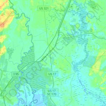
Nome: Mappa topografica Hardeeville, altitudine, rilievo.
Altitudine media: 5 m
Altitudine minima: -4 m
Altitudine massima: 27 m
The city is located on the Atlantic coastal plain, with very few variations in elevation. The average elevation of the city is approximately 20 feet (6.1 m) above mean sea level. Most of Hardeeville is located within Jasper County, though a small portion of the city crosses into Beaufort County. Much of the city is bordered to the west by the Savannah National Wildlife Refuge, a large-scale nature preserve along the South Carolina and Georgia sides of the Savannah River.
Altre mappe topografiche
Clicca su una mappa per visualizzarne la topografia, l'altitudine e il rilievo.
Ridgeland
United States > South Carolina > Jasper County
Ridgeland, Jasper County, South Carolina, United States
Altitudine media: 15 m
Latitude Margaritaville
United States > South Carolina > Jasper County > Hardeeville
Latitude Margaritaville, Hardeeville, Jasper County, South Carolina, 29927, United States
Altitudine media: 4 m