
Mappa topografica Rhinecliff
Mappa interattiva
Clicca sulla mappa per visualizzare l'altitudine.
Rhinecliff
The hamlet is demarcated by large agricultural and wooded area to the north, east, and south, and bounded by the Hudson River on the west. Steep topography, formed by contorted slate ridges and valleys, define the site-specific and seemingly random orientation of the small, frame nineteenth-century houses and winding narrow roads. The hamlet had a mid-nineteenth century building boom, but its boundaries and building density have changed very little over the last one hundred years.
A proposito di questa mappa
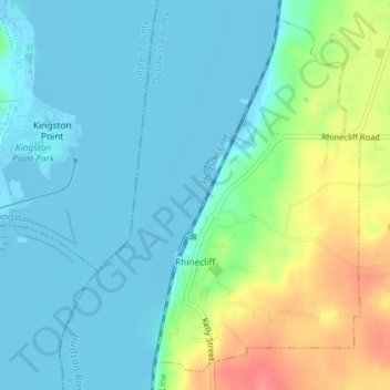
Nome: Mappa topografica Rhinecliff, altitudine, rilievo.
Altitudine media: 19 m
Altitudine minima: -9 m
Altitudine massima: 73 m
Altre mappe topografiche
Clicca su una mappa per visualizzarne la topografia, l'altitudine e il rilievo.
Drayton Grant Park at Burger Hill
United States > New York > Dutchess County > Town of Rhinebeck
Altitudine media: 102 m