
Fai una donazione
Equipaggiati per la tua prossima avventura:
In qualità di Affiliato Amazon, questo sito riceve una commissione sugli acquisti idonei, senza costi aggiuntivi per l’utente.
Mappa topografica Bullskin Township
Clicca sulla mappa per visualizzare l'altitudine.
Fai una donazione
Equipaggiati per la tua prossima avventura:
In qualità di Affiliato Amazon, questo sito riceve una commissione sugli acquisti idonei, senza costi aggiuntivi per l’utente.
Bullskin Township
Bullskin Township is in northeastern Fayette County, bordered to the north by Westmoreland County. The eastern border of the township follows the crest of Chestnut Ridge, reaching elevations of 2,340 feet (710 m) above sea level. According to the United States Census Bureau, the township has a total area of 43.64 square miles (113.02 km2), of which 43.53 square miles (112.75 km2) is land and 0.11 square miles (0.272 km2), or 0.24%, is water.
Fai una donazione
Equipaggiati per la tua prossima avventura:
In qualità di Affiliato Amazon, questo sito riceve una commissione sugli acquisti idonei, senza costi aggiuntivi per l’utente.
A proposito di questa mappa
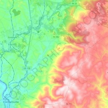
Nome: Mappa topografica Bullskin Township, altitudine, rilievo.
Altitudine media: 458 m
Altitudine minima: 258 m
Altitudine massima: 713 m
Fai una donazione
Equipaggiati per la tua prossima avventura:
In qualità di Affiliato Amazon, questo sito riceve una commissione sugli acquisti idonei, senza costi aggiuntivi per l’utente.
Altre mappe topografiche
Clicca su una mappa per visualizzarne la topografia, l'altitudine e il rilievo.
Normalville
United States > Pennsylvania > Fayette County > Springfield Township
Altitudine media: 486 m
Arnold City
United States > Pennsylvania > Fayette County > Washington Township
Altitudine media: 303 m
Fai una donazione
Equipaggiati per la tua prossima avventura:
In qualità di Affiliato Amazon, questo sito riceve una commissione sugli acquisti idonei, senza costi aggiuntivi per l’utente.
East Fredricktown
United States > Pennsylvania > Fayette County > Luzerne Township
Altitudine media: 302 m
Fai una donazione
Equipaggiati per la tua prossima avventura:
In qualità di Affiliato Amazon, questo sito riceve una commissione sugli acquisti idonei, senza costi aggiuntivi per l’utente.
Chestnut Ridge
United States > Pennsylvania > Fayette County > Redstone Township
Altitudine media: 344 m
Fai una donazione
Equipaggiati per la tua prossima avventura:
In qualità di Affiliato Amazon, questo sito riceve una commissione sugli acquisti idonei, senza costi aggiuntivi per l’utente.
Normalville
United States > Pennsylvania > Fayette County > Springfield Township
Altitudine media: 486 m
Fai una donazione
Equipaggiati per la tua prossima avventura:
In qualità di Affiliato Amazon, questo sito riceve una commissione sugli acquisti idonei, senza costi aggiuntivi per l’utente.