
Mappa topografica Hayden Valley
Mappa interattiva
Clicca sulla mappa per visualizzare l'altitudine.
A proposito di questa mappa
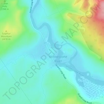
Nome: Mappa topografica Hayden Valley, altitudine, rilievo.
Luogo: Hayden Valley, Park County, Wyoming, United States (44.63362 -110.46622 44.65362 -110.44622)
Altitudine media: 2’373 m
Altitudine minima: 2’339 m
Altitudine massima: 2’481 m
A grassy valley, branching between low ridges, running from the river toward the center of the basin. A small stream rose in this valley, breaking through the ridges to the west in a deep cañon, and falling into the channel of the Yellowstone, which here bears in a northeast course, flowing in view as far as the confluence of the small stream, thence plunged into the Grand Cañon, and hidden from sight. No falls can be seen, but their location is readily detected by the sudden disappearance of the river; beyond this open valley the basin appears to be filled with a succession of low, converging ridges, heavily timbered, and all of about an equal altitude. To the south appears a broad sheet of water -- the Yellowstone Lake.
Altre mappe topografiche
Clicca su una mappa per visualizzarne la topografia, l'altitudine e il rilievo.
Cody
United States > Wyoming > Park County
Cody, Park County, Wyoming, United States
Altitudine media: 1’557 m
Lamar Valley
United States > Wyoming > Park County
Lamar Valley, Park County, Wyoming, United States
Altitudine media: 2’029 m
Tower Junction
United States > Wyoming > Park County
Tower Junction, Park County, Wyoming, United States
Altitudine media: 2’011 m
Dome Mountain
United States > Wyoming > Park County
Dome Mountain, Park County, Wyoming, United States
Altitudine media: 2’647 m
Terrace Mountain
United States > Wyoming > Park County
Terrace Mountain, Park County, Wyoming, United States
Altitudine media: 2’298 m