
Mappa topografica City of White Plains
Mappa interattiva
Clicca sulla mappa per visualizzare l'altitudine.
A proposito di questa mappa
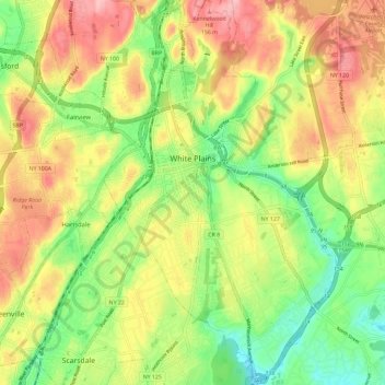
Nome: Mappa topografica City of White Plains, altitudine, rilievo.
Altitudine media: 83 m
Altitudine minima: 16 m
Altitudine massima: 158 m
Altre mappe topografiche
Clicca su una mappa per visualizzarne la topografia, l'altitudine e il rilievo.
Cecil Park
United States > New York > Westchester County > City of Yonkers
Cecil Park, City of Yonkers, Westchester County, New York, 10707, United States
Altitudine media: 70 m
Chester Heights
United States > New York > Westchester County > City of New Rochelle
Chester Heights, City of New Rochelle, Westchester County, New York, 10801, United States
Altitudine media: 36 m
Village of Buchanan
United States > New York > Westchester County > Town of Cortlandt
Village of Buchanan, Town of Cortlandt, Westchester County, New York, 10511, United States
Altitudine media: 28 m
Lincoln
United States > New York > Westchester County > City of Yonkers
Lincoln, City of Yonkers, Westchester County, New York, 10705, United States
Altitudine media: 49 m
Village of Scarsdale
United States > New York > Westchester County
Village of Scarsdale, Westchester County, New York, 10583, United States
Altitudine media: 76 m
Town of Mount Pleasant
United States > New York > Westchester County > Town of Mount Pleasant
Town of Mount Pleasant, Westchester County, New York, United States
Altitudine media: 95 m
Village of Ossining
United States > New York > Westchester County
Village of Ossining, Town of Ossining, Westchester County, New York, 10562, United States
Altitudine media: 61 m
Yonkers
United States > New York > Westchester County > Yonkers
Yonkers, Westchester County, New York, United States
Altitudine media: 58 m