
Mappa topografica Belton
Mappa interattiva
Clicca sulla mappa per visualizzare l'altitudine.
A proposito di questa mappa
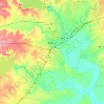
Nome: Mappa topografica Belton, altitudine, rilievo.
Luogo: Belton, Bell County, Texas, United States (30.96710 -97.55972 31.11892 -97.42600)
Altitudine media: 179 m
Altitudine minima: 133 m
Altitudine massima: 255 m
Belton is located 60 miles (97 km) north of Austin, 137 miles (220 km) south of Dallas, and 184 miles (296 km) west of Houston. It is near the center of Bell County at 31°3′32″N 97°27′48″W / 31.05889°N 97.46333°W / 31.05889; -97.46333 (31.058904, –97.463382). It is at the point where the Blackland Prairie, characterized by level ground and deep fertile soil, and the Edwards Plateau, characterized by its many springs, hills, and steep canyons, meet. Its elevation is approximately 509 feet (155 m).
Altre mappe topografiche
Clicca su una mappa per visualizzarne la topografia, l'altitudine e il rilievo.
Temple
United States > Texas > Bell County
Temple, Bell County, Texas, United States
Altitudine media: 186 m
Killeen
United States > Texas > Bell County
Killeen, Bell County, Texas, United States
Altitudine media: 266 m