
Fai una donazione
Equipaggiati per la tua prossima avventura:
In qualità di Affiliato Amazon, questo sito riceve una commissione sugli acquisti idonei, senza costi aggiuntivi per l’utente.
Mappa topografica Pittman Center
Clicca sulla mappa per visualizzare l'altitudine.
Fai una donazione
Equipaggiati per la tua prossima avventura:
In qualità di Affiliato Amazon, questo sito riceve una commissione sugli acquisti idonei, senza costi aggiuntivi per l’utente.
A proposito di questa mappa
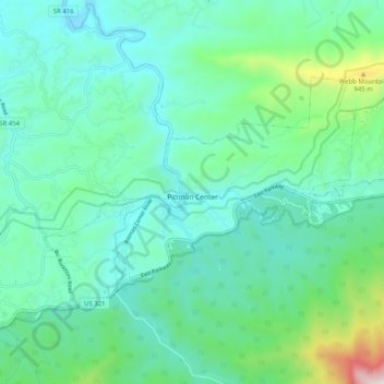
Nome: Mappa topografica Pittman Center, altitudine, rilievo.
Altitudine media: 537 m
Altitudine minima: 329 m
Altitudine massima: 1’379 m
Fai una donazione
Equipaggiati per la tua prossima avventura:
In qualità di Affiliato Amazon, questo sito riceve una commissione sugli acquisti idonei, senza costi aggiuntivi per l’utente.
Altre mappe topografiche
Clicca su una mappa per visualizzarne la topografia, l'altitudine e il rilievo.
Fai una donazione
Equipaggiati per la tua prossima avventura:
In qualità di Affiliato Amazon, questo sito riceve una commissione sugli acquisti idonei, senza costi aggiuntivi per l’utente.
Fai una donazione
Equipaggiati per la tua prossima avventura:
In qualità di Affiliato Amazon, questo sito riceve una commissione sugli acquisti idonei, senza costi aggiuntivi per l’utente.
Mount Le Conte
United States > Tennessee > Sevier County
Mount Le Conte (or LeConte) is a mountain located within the Great Smoky Mountains National Park in Sevier County, Tennessee. At 6,593 ft (2,010 m) it is the third highest peak in the national park, behind Kuwohi (formerly Clingmans Dome) (6,643 ft (2,025 m)) and Mount Guyot (6,621 ft (2,018 m)). It is also…
Altitudine media: 1’661 m
Fai una donazione
Equipaggiati per la tua prossima avventura:
In qualità di Affiliato Amazon, questo sito riceve una commissione sugli acquisti idonei, senza costi aggiuntivi per l’utente.
Sugarlands
United States > Tennessee > Sevier County
In the 19the century, mountain areas became popular vacation destinations, especially since large urban areas were often wanting for clean air and scenery. Mineral-rich mountain springs were thought to have health-restoring qualities, and the cool air of the higher elevations lured people seeking relief from…
Altitudine media: 607 m
Fai una donazione
Equipaggiati per la tua prossima avventura:
In qualità di Affiliato Amazon, questo sito riceve una commissione sugli acquisti idonei, senza costi aggiuntivi per l’utente.
Douglas Dam
United States > Tennessee > Sevier County > Sevierville
The Douglas Project required the construction of ten smaller, earthen saddle dams to fill in gaps along the adjacent ridgeline and permit a higher water elevation than would otherwise be possible. Most of these saddle dams are located in the hills southeast of the main dam. One protects downtown Dandridge,…
Altitudine media: 312 m
Fai una donazione
Equipaggiati per la tua prossima avventura:
In qualità di Affiliato Amazon, questo sito riceve una commissione sugli acquisti idonei, senza costi aggiuntivi per l’utente.
Sugarlands
United States > Tennessee > Sevier County
In the 19the century, mountain areas became popular vacation destinations, especially since large urban areas were often wanting for clean air and scenery. Mineral-rich mountain springs were thought to have health-restoring qualities, and the cool air of the higher elevations lured people seeking relief from…
Altitudine media: 607 m
Fai una donazione
Equipaggiati per la tua prossima avventura:
In qualità di Affiliato Amazon, questo sito riceve una commissione sugli acquisti idonei, senza costi aggiuntivi per l’utente.
Fai una donazione
Equipaggiati per la tua prossima avventura:
In qualità di Affiliato Amazon, questo sito riceve una commissione sugli acquisti idonei, senza costi aggiuntivi per l’utente.
Conner Heights
United States > Tennessee > Sevier County > Pigeon Forge > Conner Heights
Altitudine media: 372 m