
Mappa topografica North Bergen
Mappa interattiva
Clicca sulla mappa per visualizzare l'altitudine.
A proposito di questa mappa
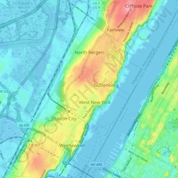
Nome: Mappa topografica North Bergen, altitudine, rilievo.
Luogo: North Bergen, Hudson County, New Jersey, United States (40.75737 -74.05688 40.82357 -73.98487)
Altitudine media: 22 m
Altitudine minima: -4 m
Altitudine massima: 99 m
North Bergen has diverse geological features. Partially situated on the Hudson River, the Hudson Palisades rise from the waterfront, while the northern part of the town sits atop the plateau. The cuesta, or slope, on its west side makes North Bergen the city with the second-most hills per square mile in the United States after San Francisco, some of which are extremely steep. A rock formation along the slope (located at 40°48′27″N 74°01′05″W / 40.80750°N 74.01806°W / 40.80750; -74.01806 (Rock formation in North Bergen)) is composed of unusual serpentinite rock and made up of small rock cliffs. Because of this, it is one of the few undeveloped parts of North Bergen. Low-lying areas along the west side are part of the New Jersey Meadowlands. The unusual shape and diverse topography of North Bergen have created diverse historical and contemporary neighborhoods:
Altre mappe topografiche
Clicca su una mappa per visualizzarne la topografia, l'altitudine e il rilievo.
Hoboken
United States > New Jersey > Hudson County
Hoboken, Hudson County, New Jersey, 07030, United States
Altitudine media: 14 m
Weehawken
United States > New Jersey > Hudson County
Weehawken, Hudson County, New Jersey, 07086, United States
Altitudine media: 27 m
Union City
United States > New Jersey > Hudson County
Union City, Hudson County, New Jersey, 07087, United States
Altitudine media: 26 m
Jersey City
United States > New Jersey > Hudson County > Jersey City
Jersey City, Hudson County, New Jersey, 07302, United States
Altitudine media: 21 m
West New York
United States > New Jersey > Hudson County
West New York, Hudson County, New Jersey, United States
Altitudine media: 35 m