
Fai una donazione
Equipaggiati per la tua prossima avventura:
In qualità di Affiliato Amazon, questo sito riceve una commissione sugli acquisti idonei, senza costi aggiuntivi per l’utente.
Mappa topografica Ansonia
Clicca sulla mappa per visualizzare l'altitudine.
Fai una donazione
Equipaggiati per la tua prossima avventura:
In qualità di Affiliato Amazon, questo sito riceve una commissione sugli acquisti idonei, senza costi aggiuntivi per l’utente.
A proposito di questa mappa
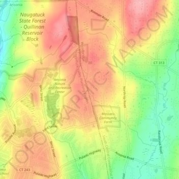
Nome: Mappa topografica Ansonia, altitudine, rilievo.
Altitudine media: 111 m
Altitudine minima: 43 m
Altitudine massima: 162 m
Fai una donazione
Equipaggiati per la tua prossima avventura:
In qualità di Affiliato Amazon, questo sito riceve una commissione sugli acquisti idonei, senza costi aggiuntivi per l’utente.
Altre mappe topografiche
Clicca su una mappa per visualizzarne la topografia, l'altitudine e il rilievo.
Guilford
United States > Connecticut > South Central Connecticut Planning Region
Altitudine media: 62 m
Bethany
United States > Connecticut > South Central Connecticut Planning Region
Altitudine media: 162 m
Wallingford
United States > Connecticut > South Central Connecticut Planning Region
Altitudine media: 72 m
New Haven
United States > Connecticut > South Central Connecticut Planning Region
Altitudine media: 20 m
Fai una donazione
Equipaggiati per la tua prossima avventura:
In qualità di Affiliato Amazon, questo sito riceve una commissione sugli acquisti idonei, senza costi aggiuntivi per l’utente.
North Haven
United States > Connecticut > South Central Connecticut Planning Region
Altitudine media: 38 m
Sea Bluff
United States > Connecticut > South Central Connecticut Planning Region > West Haven > West Shore
Altitudine media: 14 m
Meriden
United States > Connecticut > South Central Connecticut Planning Region
Altitudine media: 88 m
Fai una donazione
Equipaggiati per la tua prossima avventura:
In qualità di Affiliato Amazon, questo sito riceve una commissione sugli acquisti idonei, senza costi aggiuntivi per l’utente.
New Haven County
United States > Connecticut > South Central Connecticut Planning Region
The terrain is mostly flat near the coast, with low hills defining the rest of the area, rising significantly only in the north of the county. The highest elevation is close to the northernmost point in the county, found at two areas of approximately 1,050 feet (320 m) above sea level in the town of Wolcott.…
Altitudine media: 87 m
Indian Neck
United States > Connecticut > South Central Connecticut Planning Region > Branford
Altitudine media: 4 m
Guilford
United States > Connecticut > South Central Connecticut Planning Region
Altitudine media: 62 m
Madison
United States > Connecticut > South Central Connecticut Planning Region
Altitudine media: 69 m
Fai una donazione
Equipaggiati per la tua prossima avventura:
In qualità di Affiliato Amazon, questo sito riceve una commissione sugli acquisti idonei, senza costi aggiuntivi per l’utente.
Woodbridge
United States > Connecticut > South Central Connecticut Planning Region
Altitudine media: 96 m
Northford
United States > Connecticut > South Central Connecticut Planning Region > North Branford
Altitudine media: 71 m
Milford
United States > Connecticut > South Central Connecticut Planning Region
Altitudine media: 18 m
North Branford
United States > Connecticut > South Central Connecticut Planning Region
Altitudine media: 68 m
Fai una donazione
Equipaggiati per la tua prossima avventura:
In qualità di Affiliato Amazon, questo sito riceve una commissione sugli acquisti idonei, senza costi aggiuntivi per l’utente.
West Haven
United States > Connecticut > South Central Connecticut Planning Region
Altitudine media: 16 m
Borough of Woodmont
United States > Connecticut > South Central Connecticut Planning Region > Milford
A majority of the borough land mass is safely above sea level. However, it does have a few low elevation areas which are subject to flooding during very heavy storm situations (Hurricanes). The most recent, circa 2013 FEMA generated flood map is shown at the right, with the borough border roughly outlined in…
Altitudine media: 3 m
Momauguin
United States > Connecticut > South Central Connecticut Planning Region > East Haven
Altitudine media: 3 m
Fai una donazione
Equipaggiati per la tua prossima avventura:
In qualità di Affiliato Amazon, questo sito riceve una commissione sugli acquisti idonei, senza costi aggiuntivi per l’utente.
Indian Cave
United States > Connecticut > South Central Connecticut Planning Region > Guilford
Altitudine media: 25 m
North Madison
United States > Connecticut > South Central Connecticut Planning Region > Madison
Altitudine media: 91 m
Nut Plains
United States > Connecticut > South Central Connecticut Planning Region > Guilford
Altitudine media: 35 m
Fort Trumbull
United States > Connecticut > South Central Connecticut Planning Region > Milford
Altitudine media: 7 m
Fai una donazione
Equipaggiati per la tua prossima avventura:
In qualità di Affiliato Amazon, questo sito riceve una commissione sugli acquisti idonei, senza costi aggiuntivi per l’utente.
Branford
United States > Connecticut > South Central Connecticut Planning Region
Altitudine media: 17 m
West Shore
United States > Connecticut > South Central Connecticut Planning Region > West Haven
Altitudine media: 9 m
North Haven Bridge
United States > Connecticut > South Central Connecticut Planning Region > North Haven
Altitudine media: 22 m
Sleeping Giant State Park
United States > Connecticut > South Central Connecticut Planning Region > Hamden
Sleeping Giant (also known as the Blue Hills and Mount Carmel), (Hobbomock in Quinnipiac), is a rugged traprock mountain with a high point of 739 feet (225 m), located eight miles (13 km) north of New Haven, Connecticut. A prominent landscape feature visible for miles, the Sleeping Giant receives its name from…
Altitudine media: 79 m
Fai una donazione
Equipaggiati per la tua prossima avventura:
In qualità di Affiliato Amazon, questo sito riceve una commissione sugli acquisti idonei, senza costi aggiuntivi per l’utente.
Meriden
United States > Connecticut > South Central Connecticut Planning Region
Altitudine media: 88 m
South End Point
United States > Connecticut > South Central Connecticut Planning Region > East Haven > Momauguin
Altitudine media: 2 m
West Haven
United States > Connecticut > South Central Connecticut Planning Region
Altitudine media: 16 m
Fai una donazione
Equipaggiati per la tua prossima avventura:
In qualità di Affiliato Amazon, questo sito riceve una commissione sugli acquisti idonei, senza costi aggiuntivi per l’utente.
New Haven
United States > Connecticut > South Central Connecticut Planning Region
Altitudine media: 20 m
Silver Beach
United States > Connecticut > South Central Connecticut Planning Region > Milford > Fort Trumbull
Altitudine media: 5 m
Branford Hills
United States > Connecticut > South Central Connecticut Planning Region > Branford
Altitudine media: 12 m
Forest Heights
United States > Connecticut > South Central Connecticut Planning Region > Milford
Altitudine media: 19 m
Fai una donazione
Equipaggiati per la tua prossima avventura:
In qualità di Affiliato Amazon, questo sito riceve una commissione sugli acquisti idonei, senza costi aggiuntivi per l’utente.
North Haven
United States > Connecticut > South Central Connecticut Planning Region
Altitudine media: 38 m
East Peak
United States > Connecticut > South Central Connecticut Planning Region > Meriden
Altitudine media: 154 m
New Haven
United States > Connecticut > South Central Connecticut Planning Region
Altitudine media: 20 m
New Haven County
United States > Connecticut > South Central Connecticut Planning Region
The terrain is mostly flat near the coast, with low hills defining the rest of the area, rising significantly only in the north of the county. The highest elevation is close to the northernmost point in the county, found at two areas of approximately 1,050 feet (320 m) above sea level in the town of Wolcott.…
Altitudine media: 87 m
Fai una donazione
Equipaggiati per la tua prossima avventura:
In qualità di Affiliato Amazon, questo sito riceve una commissione sugli acquisti idonei, senza costi aggiuntivi per l’utente.
New Haven
United States > Connecticut > South Central Connecticut Planning Region
Altitudine media: 20 m
West Haven
United States > Connecticut > South Central Connecticut Planning Region
Altitudine media: 16 m
Momauguin
United States > Connecticut > South Central Connecticut Planning Region > East Haven
Altitudine media: 3 m
Silver Beach
United States > Connecticut > South Central Connecticut Planning Region > Milford
Altitudine media: 5 m
Fai una donazione
Equipaggiati per la tua prossima avventura:
In qualità di Affiliato Amazon, questo sito riceve una commissione sugli acquisti idonei, senza costi aggiuntivi per l’utente.
Nut Plains
United States > Connecticut > South Central Connecticut Planning Region > Guilford
Altitudine media: 35 m
Woodbridge
United States > Connecticut > South Central Connecticut Planning Region
Altitudine media: 96 m
Milford
United States > Connecticut > South Central Connecticut Planning Region
Altitudine media: 18 m
Wallingford
United States > Connecticut > South Central Connecticut Planning Region
Altitudine media: 72 m
Fai una donazione
Equipaggiati per la tua prossima avventura:
In qualità di Affiliato Amazon, questo sito riceve una commissione sugli acquisti idonei, senza costi aggiuntivi per l’utente.
South Meriden
United States > Connecticut > South Central Connecticut Planning Region > Meriden
Altitudine media: 55 m
Bayview
United States > Connecticut > South Central Connecticut Planning Region > Milford
Altitudine media: 5 m
Bethany
United States > Connecticut > South Central Connecticut Planning Region
Altitudine media: 162 m
Brightview
United States > Connecticut > South Central Connecticut Planning Region > New Haven
Altitudine media: 5 m
Fai una donazione
Equipaggiati per la tua prossima avventura:
In qualità di Affiliato Amazon, questo sito riceve una commissione sugli acquisti idonei, senza costi aggiuntivi per l’utente.
Fort Trumbull
United States > Connecticut > South Central Connecticut Planning Region > Milford
Altitudine media: 7 m
Sea Bluff
United States > Connecticut > South Central Connecticut Planning Region > West Haven > West Shore
Altitudine media: 14 m
Mount Carmel Center
United States > Connecticut > South Central Connecticut Planning Region > Hamden
Altitudine media: 79 m
Fai una donazione
Equipaggiati per la tua prossima avventura:
In qualità di Affiliato Amazon, questo sito riceve una commissione sugli acquisti idonei, senza costi aggiuntivi per l’utente.
Morningside
United States > Connecticut > South Central Connecticut Planning Region > Milford
Altitudine media: 5 m
Milford
United States > Connecticut > South Central Connecticut Planning Region
Altitudine media: 18 m
East River
United States > Connecticut > South Central Connecticut Planning Region > Madison
Altitudine media: 9 m
Big Indian
United States > Connecticut > South Central Connecticut Planning Region > Guilford
Altitudine media: 41 m
Fai una donazione
Equipaggiati per la tua prossima avventura:
In qualità di Affiliato Amazon, questo sito riceve una commissione sugli acquisti idonei, senza costi aggiuntivi per l’utente.
Sunset Hill
United States > Connecticut > South Central Connecticut Planning Region > Branford
Altitudine media: 12 m
Sea Bluff
United States > Connecticut > South Central Connecticut Planning Region > West Haven > West Shore
Altitudine media: 14 m
Clark Hill
United States > Connecticut > South Central Connecticut Planning Region > Milford
Altitudine media: 11 m
Peter's Rock
United States > Connecticut > South Central Connecticut Planning Region > North Haven
Altitudine media: 38 m
Fai una donazione
Equipaggiati per la tua prossima avventura:
In qualità di Affiliato Amazon, questo sito riceve una commissione sugli acquisti idonei, senza costi aggiuntivi per l’utente.
West Haven
United States > Connecticut > South Central Connecticut Planning Region
Altitudine media: 16 m
Quinnipiac
United States > Connecticut > South Central Connecticut Planning Region > Wallingford
Altitudine media: 31 m
Milford
United States > Connecticut > South Central Connecticut Planning Region
Altitudine media: 18 m
Branford
United States > Connecticut > South Central Connecticut Planning Region
Altitudine media: 17 m
Fai una donazione
Equipaggiati per la tua prossima avventura:
In qualità di Affiliato Amazon, questo sito riceve una commissione sugli acquisti idonei, senza costi aggiuntivi per l’utente.
Fair Haven East
United States > Connecticut > South Central Connecticut Planning Region > New Haven
Altitudine media: 14 m
New Haven
United States > Connecticut > South Central Connecticut Planning Region
Altitudine media: 20 m
North Branford
United States > Connecticut > South Central Connecticut Planning Region
Altitudine media: 68 m
Allingtown
United States > Connecticut > South Central Connecticut Planning Region > West Haven
Altitudine media: 26 m
Fai una donazione
Equipaggiati per la tua prossima avventura:
In qualità di Affiliato Amazon, questo sito riceve una commissione sugli acquisti idonei, senza costi aggiuntivi per l’utente.
Meriden
United States > Connecticut > South Central Connecticut Planning Region
Altitudine media: 92 m
Milford
United States > Connecticut > South Central Connecticut Planning Region
Altitudine media: 18 m
Milford
United States > Connecticut > South Central Connecticut Planning Region
Altitudine media: 18 m
New Haven
United States > Connecticut > South Central Connecticut Planning Region
Altitudine media: 20 m
Fai una donazione
Equipaggiati per la tua prossima avventura:
In qualità di Affiliato Amazon, questo sito riceve una commissione sugli acquisti idonei, senza costi aggiuntivi per l’utente.