
Mappa topografica Deddington
Mappa interattiva
Clicca sulla mappa per visualizzare l'altitudine.
A proposito di questa mappa
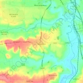
Nome: Mappa topografica Deddington, altitudine, rilievo.
Altitudine media: 107 m
Altitudine minima: 75 m
Altitudine massima: 159 m
Clifton, Deddington and Hempton stand on a ridge of Jurassic ferruginous marlstone hills between the three watercourses. Clifton is about 1+1⁄2 miles (2.4 km) east of Deddington, at the eastern end of the ridge where it slopes down to the Cherwell. The ridges rises westward. Deddington is about 430 feet (130 m) above sea level. Hempton is about 1+1⁄2 miles (2.4 km) west of Deddington and about 489 feet (149 m) above sea level. The highest point of the ridge is on the western boundary of the parish, more than 490 feet (150 m) above sea level. The parish's topography is alluded to in a local rhyme:
Altre mappe topografiche
Clicca su una mappa per visualizzarne la topografia, l'altitudine e il rilievo.
Ambrosden
United Kingdom > England > Oxfordshire > Cherwell District
Ambrosden, Cherwell District, Oxfordshire, England, United Kingdom
Altitudine media: 66 m
Cottisford
United Kingdom > England > Oxfordshire > Cherwell District
Cottisford, Cherwell District, Oxfordshire, England, United Kingdom
Altitudine media: 121 m
Launton
United Kingdom > England > Oxfordshire > Cherwell District
Launton, Cherwell District, Oxfordshire, England, United Kingdom
Altitudine media: 73 m
Kirtlington
United Kingdom > England > Oxfordshire > Cherwell District
Kirtlington, Cherwell District, Oxfordshire, England, United Kingdom
Altitudine media: 89 m
Bicester
United Kingdom > England > Oxfordshire > Cherwell District
Bicester, Cherwell District, Oxfordshire, England, United Kingdom
Altitudine media: 76 m
Adderbury
United Kingdom > England > Oxfordshire > Cherwell District
Adderbury, Cherwell District, Oxfordshire, England, United Kingdom
Altitudine media: 100 m
Banbury
United Kingdom > England > Oxfordshire > Cherwell District
Banbury, Cherwell District, Oxfordshire, England, United Kingdom
Altitudine media: 116 m