
Mappa topografica County Clare
Clicca sulla mappa per visualizzare l'altitudine.
A proposito di questa mappa
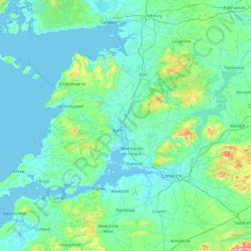
Nome: Mappa topografica County Clare, altitudine, rilievo.
Luogo: County Clare, Munster, Ireland (52.55447 -9.93876 53.16891 -8.28242)
Altitudine media: 67 m
Altitudine minima: -4 m
Altitudine massima: 862 m
Altre mappe topografiche
Clicca su una mappa per visualizzarne la topografia, l'altitudine e il rilievo.
Galtymore
Ireland > County Limerick > The Municipal District of Cappamore — Kilmallock
Galtymore or Galteemore (Irish: Cnoc Mór na nGaibhlte, meaning 'big hill of the Galtees') is a mountain in the province of Munster, Ireland. At 917.9 metres (3,011 ft 6 in), it is one of Ireland's highest mountains, being the 12th-highest on the Arderin list, and 14th-highest on the Vandeleur-Lynam list.…
Altitudine media: 594 m
Aherlow
Ireland > County Limerick > The Municipal District of Cappamore — Kilmallock
Altitudine media: 141 m
Kildare Round Tower
A Topographical Dictionary of Ireland states "One of the ancient round towers stood here till 1807 when it was pulled down to make room for the belfry of the church".
Altitudine media: 100 m