
Mappa topografica Alice
Mappa interattiva
Clicca sulla mappa per visualizzare l'altitudine.
A proposito di questa mappa
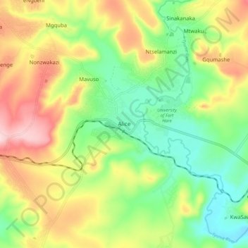
Nome: Mappa topografica Alice, altitudine, rilievo.
Altitudine media: 586 m
Altitudine minima: 480 m
Altitudine massima: 733 m
The location was named Lovedale by European missionaries who settled there in 1824.It lies on the southwestern bank of the Tyhume River, west-northwest of East London, at an elevation of 1,720(524m).It was named after John Love of the Glasgow Missionary Society. During the Frontier War it was abandoned and the mission resettled on the west bank of the Tyhume River. On the east bank a fort was built, called Fort Hare, after Major-General John Hare, who was Lieutenant-Governor of the Eastern Cape and acting Governor of the Cape Colony. Later the name of the town was changed to Alice. Alice was the administrative and magisterial capital of the old district of Victoria East. In 1847, it was named Alice by Sir Peregrine Maitland after Princess Alice, the second daughter of Queen Victoria. Municipal status was attained in 1852. The town is now a thriving university town and has received major infrastructure upgrades under the current Mayor Bandile Khethelo.
Altre mappe topografiche
Clicca su una mappa per visualizzarne la topografia, l'altitudine e il rilievo.
Hogsback
South Africa > Eastern Cape > Amathole District Municipality > Nkonkobe Local Municipality
Hogsback, Nkonkobe Local Municipality, Amathole District Municipality, Eastern Cape, 5721, South Africa
Altitudine media: 1’147 m
Kat River
South Africa > Eastern Cape > Amathole District Municipality > Nkonkobe Local Municipality
Kat River, Nkonkobe Local Municipality, Amathole District Municipality, Eastern Cape, South Africa
Altitudine media: 326 m
Fort Beaufort
South Africa > Eastern Cape > Amathole District Municipality > Nkonkobe Local Municipality > Fort Beaufort
Fort Beaufort, Nkonkobe Local Municipality, Amathole District Municipality, Eastern Cape, 5720, South Africa
Altitudine media: 482 m