
Mappa topografica Lake Of The Ozarks
Mappa interattiva
Clicca sulla mappa per visualizzare l'altitudine.
A proposito di questa mappa
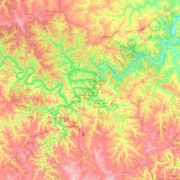
Nome: Mappa topografica Lake Of The Ozarks, altitudine, rilievo.
Altitudine media: 265 m
Altitudine minima: 163 m
Altitudine massima: 381 m
The lake was created by the construction of the 2,543-foot (775 m) long Bagnell Dam by the Union Electric Company of St. Louis, Missouri. The principal engineering firm was Stone and Webster. Construction began August 8, 1929, and was completed in April 1931; the lake reached spillway elevation on May 20, 1931.