
Mappa topografica Ellens Green
Clicca sulla mappa per visualizzare l'altitudine.
A proposito di questa mappa
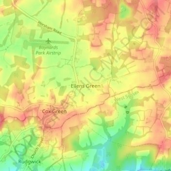
Nome: Mappa topografica Ellens Green, altitudine, rilievo.
Altitudine media: 67 m
Altitudine minima: 28 m
Altitudine massima: 95 m
Altre mappe topografiche
Clicca su una mappa per visualizzarne la topografia, l'altitudine e il rilievo.
Cranleigh
United Kingdom > England > Surrey > Waverley
Elevations range from a maximum of 240 m AOD (mean high water level) at the car park on Reynolds Hill in Winterfold Heath (a woodland in the north) to 41 m on the watercourse and the disused Wey and Arun Canal as they leave both the parish in the northwest extreme at the end of East Whipley Lane. The village…
Altitudine media: 78 m
Farnham
United Kingdom > England > Surrey > Waverley
Farnham lies in the valley of the North Branch of the River Wey, which rises near Alton, merges with the South Branch at Tilford, and joins the River Thames at Weybridge. The mainly east-west alignment of the ridges and valleys has influenced the development of road and rail communications. The most prominent…
Altitudine media: 100 m
Godalming
United Kingdom > England > Surrey > Waverley
Elevations vary between 36 m (118 ft) AOD by the Guildford Road Rugby Union ground and Broadwater lake at the River Wey's exit from Godalming into Peasmarsh, Shalford, and 106 m (347.76 ft) AOD where Quarter Mile meets Hambledon Road (both residential) in the south-east. Hurtmore Road is also residential:…
Altitudine media: 71 m
Haslemere
United Kingdom > England > Surrey > Waverley > Shottermill
Many of the roads in the area originated as medieval tracks and owing to the local topography, are narrow, twisting and steep. The principal route through Haslemere is the A286, which connects the town with Godalming and Grayswood (to the north) and with Midhurst (to the south). The A287 runs south from…
Altitudine media: 150 m
Hankley Common
United Kingdom > England > Surrey > Waverley > Thursley > Truxford
Altitudine media: 70 m
Witley
United Kingdom > England > Surrey > Waverley
In 1848, Samuel Lewis's "topographical dictionary of England" describes Witley as
Altitudine media: 89 m
Dunsfold
United Kingdom > England > Surrey > Waverley
St Mary & All Saints' Church is a Norman building, containing the oldest pews in England. The nearby Holy Well was a site of pilgrimage – its waters were thought to cure diseases of the eye. It would be consistent with the topography of the site that the well be a pre-Christian site and the church itself be…
Altitudine media: 52 m
Farnham
United Kingdom > England > Surrey > Waverley > Hale
Farnham lies in the valley of the North Branch of the River Wey, which rises near Alton, merges with the South Branch at Tilford, and joins the River Thames at Weybridge. The mainly east–west alignment of the ridges and valleys has influenced the development of road and rail communications. The most…
Altitudine media: 100 m
Haslemere
United Kingdom > England > Surrey > Waverley > Shottermill
Many of the roads in the area originated as medieval tracks and owing to the local topography, are narrow, twisting and steep. The principal route through Haslemere is the A286, which connects the town with Godalming and Grayswood (to the north) and with Midhurst (to the south). The A287 runs south from…
Altitudine media: 150 m
Cranleigh
United Kingdom > England > Surrey > Waverley
Elevations range from a maximum of 240 m AOD (mean high water level) at the car park on Reynolds Hill in Winterfold Heath (a woodland in the north) to 41 m on the watercourse and the disused Wey and Arun Canal as they leave both the parish in the northwest extreme at the end of East Whipley Lane. The village…
Altitudine media: 78 m
Haslemere
United Kingdom > England > Surrey > Waverley
Many of the roads in the area originated as medieval tracks and owing to the local topography, are narrow, twisting and steep. The principal route through Haslemere is the A286, which connects the town with Godalming and Grayswood (to the north) and with Midhurst (to the south). The A287 runs south from…
Altitudine media: 150 m
Cranleigh
United Kingdom > England > Surrey > Waverley
Elevations range from a maximum of 240 m AOD (mean high water level) at the car park on Reynolds Hill in Winterfold Heath (a woodland in the north) to 41 m on the watercourse and the disused Wey and Arun Canal as they leave both the parish in the northwest extreme at the end of East Whipley Lane. The village…
Altitudine media: 78 m
Haslemere
United Kingdom > England > Surrey > Waverley
Many of the roads in the area originated as medieval tracks and owing to the local topography, are narrow, twisting and steep. The principal route through Haslemere is the A286, which connects the town with Godalming and Grayswood (to the north) and with Midhurst (to the south). The A287 runs south from…
Altitudine media: 150 m
Wonersh
United Kingdom > England > Surrey > Waverley
The parish rises from west to east up the eroded basin of Cranleigh Waters holding the villages to the flint, clay, greensand and sandy soil topped Greensand Ridge. Elevations vary from 39 m (128 ft) AOD by the Bramley/Wonersh bridge over the stream to 207 m (679 ft) at the car park on Winterfold Hill,…
Altitudine media: 79 m
Floodplain (seasonal)
United Kingdom > England > Surrey > Waverley > Farnham > Wrecclesham
Altitudine media: 94 m
Haslemere
United Kingdom > England > Surrey > Waverley
Many of the roads in the area originated as medieval tracks and owing to the local topography, are narrow, twisting and steep. The principal route through Haslemere is the A286, which connects the town with Godalming and Grayswood (to the north) and with Midhurst (to the south). The A287 runs south from…
Altitudine media: 150 m