
Fai una donazione
Equipaggiati per la tua prossima avventura:
In qualità di Affiliato Amazon, questo sito riceve una commissione sugli acquisti idonei, senza costi aggiuntivi per l’utente.
Mappa topografica Dhari
Clicca sulla mappa per visualizzare l'altitudine.
Fai una donazione
Equipaggiati per la tua prossima avventura:
In qualità di Affiliato Amazon, questo sito riceve una commissione sugli acquisti idonei, senza costi aggiuntivi per l’utente.
Dhari
Dhari is located at 21°19′36″N 71°01′31″E / 21.3266°N 71.0253°E / 21.3266; 71.0253. It has an average elevation of 216m (708') above sea level. The city is located in Saurashtra region of Gujarat and is situated near the Shetrunji River, which is passes north of Palitana's hills, Shatrunjaya, then in a southeasterly direction past Talaja Hill, through a peninsula, before reaching the Gulf of Cambay, approximately 9.7 km (6 mi) north of Goapnath Point. The weather in Dhari is sunny from September to May, and rainy from June to August. The average maximum and minimum temperatures are 46 °C (114.8 °F) and 5 °C (48 °F) respectively. The average annual rainfall is about 800 millimetres (31 in).
Fai una donazione
Equipaggiati per la tua prossima avventura:
In qualità di Affiliato Amazon, questo sito riceve una commissione sugli acquisti idonei, senza costi aggiuntivi per l’utente.
A proposito di questa mappa
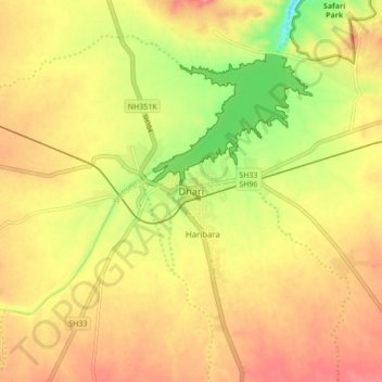
Nome: Mappa topografica Dhari, altitudine, rilievo.
Luogo: Dhari, Dhari Taluka, Amreli, Gujarat, 364640, India (21.28807 70.98622 21.36807 71.06622)
Altitudine media: 221 m
Altitudine minima: 163 m
Altitudine massima: 263 m
Fai una donazione
Equipaggiati per la tua prossima avventura:
In qualità di Affiliato Amazon, questo sito riceve una commissione sugli acquisti idonei, senza costi aggiuntivi per l’utente.