
Mappa topografica Wichenford
Clicca sulla mappa per visualizzare l'altitudine.
A proposito di questa mappa
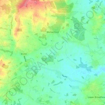
Nome: Mappa topografica Wichenford, altitudine, rilievo.
Altitudine media: 58 m
Altitudine minima: 32 m
Altitudine massima: 115 m
Altre mappe topografiche
Clicca su una mappa per visualizzarne la topografia, l'altitudine e il rilievo.
Upper Broadheath
United Kingdom > England > Worcestershire > Malvern Hills > Crown East
Altitudine media: 44 m
Malvern
United Kingdom > England > Worcestershire > Malvern Hills
Malvern lies in the Lower Severn/Avon plain affording it a degree of shelter caused by virtue of its nestling in between the Cotswold hills to the east, the Welsh Hills and Mountains to the west, and Birmingham plateau to the north. Although as with all the British Isles it has a maritime climate, the local…
Altitudine media: 95 m
Kerswell Green
United Kingdom > England > Worcestershire > Malvern Hills > Kempsey
Altitudine media: 25 m
Corse Lawn
United Kingdom > England > Worcestershire > Malvern Hills > Eldersfield
Altitudine media: 26 m
The Hill, Abberley
United Kingdom > England > Worcestershire > Malvern Hills > Abberley
Altitudine media: 132 m
Elms Green
United Kingdom > England > Worcestershire > Malvern Hills > Abberley
Altitudine media: 121 m
Table Hill
United Kingdom > England > Worcestershire > Malvern Hills
Table Hill is situated in the range of Malvern Hills that runs about 13 kilometres (8 mi) north-south along the Herefordshire-Worcestershire border. It lies between North Hill and Sugarloaf Hill and has an elevation of 373 metres (1,224 ft).
Altitudine media: 188 m
Malvern
United Kingdom > England > Worcestershire > Malvern Hills
Malvern lies in the Lower Severn/Avon plain affording it a degree of shelter caused by virtue of its nestling in between the Cotswold hills to the east, the Welsh Hills and Mountains to the west, and Birmingham plateau to the north. Although as with all the British Isles it has a maritime climate, the local…
Altitudine media: 95 m
Worcestershire Beacon
United Kingdom > England > Worcestershire > Malvern Hills
Altitudine media: 197 m
Malvern
United Kingdom > England > Worcestershire > Malvern Hills
Malvern lies in the Lower Severn/Avon plain affording it a degree of shelter caused by virtue of its nestling in between the Cotswold hills to the east, the Welsh Hills and Mountains to the west, and Birmingham plateau to the north. Although as with all the British Isles it has a maritime climate, the local…
Altitudine media: 95 m