
Mappa topografica Tulsa
Mappa interattiva
Clicca sulla mappa per visualizzare l'altitudine.
A proposito di questa mappa
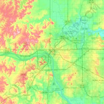
Nome: Mappa topografica Tulsa, altitudine, rilievo.
Luogo: Tulsa, Tulsa County, Oklahoma, United States (35.96830 -96.07448 36.33651 -95.68160)
Altitudine media: 221 m
Altitudine minima: 166 m
Altitudine massima: 321 m
Tulsa is located in the northeastern corner of Oklahoma between the edge of the Great Plains and the foot of the Ozarks in a generally forested region of rolling hills. The city touches the eastern extent of the Cross Timbers, an ecoregion of forest and prairie transitioning from the drier plains of the west to the wetter forests of the east. With a wetter climate than points westward, Tulsa serves as a gateway to "Green Country", a popular and official designation for northeast Oklahoma that stems from the region's green vegetation and relatively large number of hills and lakes compared to central and western areas of Oklahoma, which lie largely in the drier Great Plains region of the Central United States. Located near the western edge of the U.S. Interior Highlands, northeastern Oklahoma is the most topographically diverse part of the state, containing seven of Oklahoma's 11 eco-regions and more than half of its state parks. The region encompasses 30 lakes or reservoirs and borders the neighboring states of Kansas, Missouri, and Arkansas. The geographic coordinates of the city of Tulsa are 36°7′53″N 95°56′14″W / 36.13139°N 95.93722°W / 36.13139; -95.93722 (36.131294, −95.937332), with an elevation of 700 feet (210 m) above sea level.