
Fai una donazione
Equipaggiati per la tua prossima avventura:
In qualità di Affiliato Amazon, questo sito riceve una commissione sugli acquisti idonei, senza costi aggiuntivi per l’utente.
Mappa topografica Ashburn
Clicca sulla mappa per visualizzare l'altitudine.
Fai una donazione
Equipaggiati per la tua prossima avventura:
In qualità di Affiliato Amazon, questo sito riceve una commissione sugli acquisti idonei, senza costi aggiuntivi per l’utente.
Ashburn
Ashburn is located in eastern Loudoun County at 39°02′37″N 077°29′15″W / 39.04361°N 77.48750°W / 39.04361; -77.48750 (39.0437192, −77.4874899) and its average elevation is 295 feet (90 m) above sea level. It is 7 miles (11 km) southeast of Leesburg, the county seat, and the same distance north of Dulles International Airport. As drawn by the U.S. Census Bureau, the area counted as "Ashburn" extends north to Virginia State Route 7, east to Virginia State Route 28, and southwest to the Dulles Greenway (VA 267). The Ashburn CDP is bordered to the north by the Belmont, Lansdowne, One Loudoun, and University Center CDPs; to the east by the Kincora, Dulles Town Center, and Sterling CDPs; to the southwest by the Moorefield and Broadlands CDPs; and to the west by the Goose Creek Village CDP.
Fai una donazione
Equipaggiati per la tua prossima avventura:
In qualità di Affiliato Amazon, questo sito riceve una commissione sugli acquisti idonei, senza costi aggiuntivi per l’utente.
A proposito di questa mappa
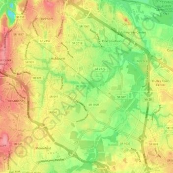
Nome: Mappa topografica Ashburn, altitudine, rilievo.
Luogo: Ashburn, Loudoun County, Virginia, United States (38.98815 -77.52292 39.07145 -77.43125)
Altitudine media: 86 m
Altitudine minima: 36 m
Altitudine massima: 144 m
Fai una donazione
Equipaggiati per la tua prossima avventura:
In qualità di Affiliato Amazon, questo sito riceve una commissione sugli acquisti idonei, senza costi aggiuntivi per l’utente.