
Fai una donazione
Equipaggiati per la tua prossima avventura:
In qualità di Affiliato Amazon, questo sito riceve una commissione sugli acquisti idonei, senza costi aggiuntivi per l’utente.
Mappa topografica Shelton
Clicca sulla mappa per visualizzare l'altitudine.
Fai una donazione
Equipaggiati per la tua prossima avventura:
In qualità di Affiliato Amazon, questo sito riceve una commissione sugli acquisti idonei, senza costi aggiuntivi per l’utente.
A proposito di questa mappa
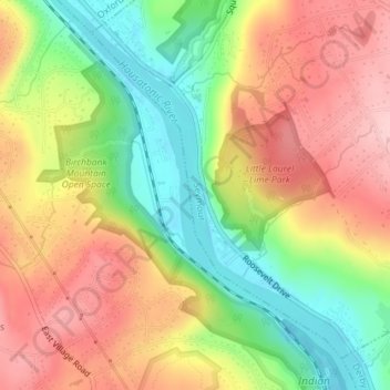
Nome: Mappa topografica Shelton, altitudine, rilievo.
Altitudine media: 96 m
Altitudine minima: 1 m
Altitudine massima: 185 m
Fai una donazione
Equipaggiati per la tua prossima avventura:
In qualità di Affiliato Amazon, questo sito riceve una commissione sugli acquisti idonei, senza costi aggiuntivi per l’utente.
Altre mappe topografiche
Clicca su una mappa per visualizzarne la topografia, l'altitudine e il rilievo.
Watertown
United States > Connecticut > Naugatuck Valley Planning Region
Watertown is in southeastern Litchfield County and is bordered to the southeast by the city of Waterbury in New Haven County. Other bordering towns are Middlebury to the south, Woodbury and Bethlehem to the west, Morris to the northwest, and Thomaston to the east. It is in the Eastern Standard time zone. The…
Altitudine media: 199 m
Fai una donazione
Equipaggiati per la tua prossima avventura:
In qualità di Affiliato Amazon, questo sito riceve una commissione sugli acquisti idonei, senza costi aggiuntivi per l’utente.
Derby
United States > Connecticut > Naugatuck Valley Planning Region
According to the United States Census Bureau, the town has a total area of 5.4 square miles (8.7 km2), of which, 5.0 square miles (13 km2) is land and 0.4 square miles (1.0 km2) (7.41%) is water. The city is home to the 417 acres (0.652 sq mi) Osbornedale State Park. Derby is divided into two main sections by…
Altitudine media: 78 m
Huntington
United States > Connecticut > Naugatuck Valley Planning Region > Shelton
Altitudine media: 111 m
Fai una donazione
Equipaggiati per la tua prossima avventura:
In qualità di Affiliato Amazon, questo sito riceve una commissione sugli acquisti idonei, senza costi aggiuntivi per l’utente.
Naugatuck State Forest
United States > Connecticut > Naugatuck Valley Planning Region > Beacon Falls
Altitudine media: 137 m
Minortown
United States > Connecticut > Naugatuck Valley Planning Region > Woodbury
Altitudine media: 169 m
Wolcott
United States > Connecticut > Naugatuck Valley Planning Region
The highest point in New Haven County is found in Wolcott atop Lindsley Hill, which has an elevation of approximately 1,046 feet above sea level.
Altitudine media: 209 m
Fai una donazione
Equipaggiati per la tua prossima avventura:
In qualità di Affiliato Amazon, questo sito riceve una commissione sugli acquisti idonei, senza costi aggiuntivi per l’utente.
Prospect
United States > Connecticut > Naugatuck Valley Planning Region
According to the Köppen classification, Prospect is Dfb, or a humid continental climate. The town has warm and humid summers with cold winters. Precipitation is spread throughout the year, with thunderstorms frequent during the summer months, and heavy snowfalls during the winter months. Due to Prospect's…
Altitudine media: 193 m
Oakville
United States > Connecticut > Naugatuck Valley Planning Region > Watertown > Oakville
Altitudine media: 172 m
White Hills
United States > Connecticut > Naugatuck Valley Planning Region > Shelton
Altitudine media: 124 m
Fai una donazione
Equipaggiati per la tua prossima avventura:
In qualità di Affiliato Amazon, questo sito riceve una commissione sugli acquisti idonei, senza costi aggiuntivi per l’utente.
Fai una donazione
Equipaggiati per la tua prossima avventura:
In qualità di Affiliato Amazon, questo sito riceve una commissione sugli acquisti idonei, senza costi aggiuntivi per l’utente.
Fai una donazione
Equipaggiati per la tua prossima avventura:
In qualità di Affiliato Amazon, questo sito riceve una commissione sugli acquisti idonei, senza costi aggiuntivi per l’utente.
Prospect
United States > Connecticut > Naugatuck Valley Planning Region
According to the Köppen classification, Prospect is Dfb, or a humid continental climate. The town has warm and humid summers with cold winters. Precipitation is spread throughout the year, with thunderstorms frequent during the summer months, and heavy snowfalls during the winter months. Due to Prospect's…
Altitudine media: 193 m
Fai una donazione
Equipaggiati per la tua prossima avventura:
In qualità di Affiliato Amazon, questo sito riceve una commissione sugli acquisti idonei, senza costi aggiuntivi per l’utente.
Wolcott
United States > Connecticut > Naugatuck Valley Planning Region
The highest point in New Haven County is found in Wolcott atop Lindsley Hill, which has an elevation of approximately 1,046 feet above sea level.
Altitudine media: 209 m
Fox Hollow
United States > Connecticut > Naugatuck Valley Planning Region > Cheshire
Altitudine media: 64 m
Westview Heights
United States > Connecticut > Naugatuck Valley Planning Region > Middlebury
Altitudine media: 159 m
Fai una donazione
Equipaggiati per la tua prossima avventura:
In qualità di Affiliato Amazon, questo sito riceve una commissione sugli acquisti idonei, senza costi aggiuntivi per l’utente.
Union City
United States > Connecticut > Naugatuck Valley Planning Region > Naugatuck
Altitudine media: 124 m
Warsaw Park
United States > Connecticut > Naugatuck Valley Planning Region > Ansonia
Altitudine media: 107 m
Bunker Hill
United States > Connecticut > Naugatuck Valley Planning Region > Waterbury
Altitudine media: 140 m
Cedar Land
United States > Connecticut > Naugatuck Valley Planning Region > Southbury
Altitudine media: 103 m
Fai una donazione
Equipaggiati per la tua prossima avventura:
In qualità di Affiliato Amazon, questo sito riceve una commissione sugli acquisti idonei, senza costi aggiuntivi per l’utente.
Town Plot Hill
United States > Connecticut > Naugatuck Valley Planning Region > Waterbury
Altitudine media: 127 m
Millville
United States > Connecticut > Naugatuck Valley Planning Region > Naugatuck
Altitudine media: 132 m
Bunker Hill
United States > Connecticut > Naugatuck Valley Planning Region > Waterbury
Altitudine media: 140 m
Fai una donazione
Equipaggiati per la tua prossima avventura:
In qualità di Affiliato Amazon, questo sito riceve una commissione sugli acquisti idonei, senza costi aggiuntivi per l’utente.
Bunker Hill
United States > Connecticut > Naugatuck Valley Planning Region > Waterbury
Altitudine media: 140 m
Traditions
United States > Connecticut > Naugatuck Valley Planning Region > Southbury > South Britain
Altitudine media: 112 m
Fai una donazione
Equipaggiati per la tua prossima avventura:
In qualità di Affiliato Amazon, questo sito riceve una commissione sugli acquisti idonei, senza costi aggiuntivi per l’utente.
Minortown
United States > Connecticut > Naugatuck Valley Planning Region > Woodbury
Altitudine media: 169 m
Derby
United States > Connecticut > Naugatuck Valley Planning Region
According to the United States Census Bureau, the town has a total area of 5.4 square miles (8.7 km2), of which, 5.0 square miles (13 km2) is land and 0.4 square miles (1.0 km2) (7.41%) is water. The city is home to the 417 acres (0.652 sq mi) Osbornedale State Park. Derby is divided into two main sections by…
Altitudine media: 78 m
Gulls Hollow
United States > Connecticut > Naugatuck Valley Planning Region > Bethlehem
Altitudine media: 243 m
Fai una donazione
Equipaggiati per la tua prossima avventura:
In qualità di Affiliato Amazon, questo sito riceve una commissione sugli acquisti idonei, senza costi aggiuntivi per l’utente.
Allentown
United States > Connecticut > Naugatuck Valley Planning Region > Plymouth
Altitudine media: 244 m
Wolcott
United States > Connecticut > Naugatuck Valley Planning Region
The highest point in New Haven County is found in Wolcott atop Lindsley Hill, which has an elevation of approximately 1,046 feet above sea level.
Altitudine media: 209 m
Fai una donazione
Equipaggiati per la tua prossima avventura:
In qualità di Affiliato Amazon, questo sito riceve una commissione sugli acquisti idonei, senza costi aggiuntivi per l’utente.