
Mappa topografica Pleasley Vale
Clicca sulla mappa per visualizzare l'altitudine.
A proposito di questa mappa
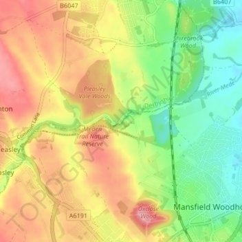
Nome: Mappa topografica Pleasley Vale, altitudine, rilievo.
Altitudine media: 115 m
Altitudine minima: 67 m
Altitudine massima: 162 m
Altre mappe topografiche
Clicca su una mappa per visualizzarne la topografia, l'altitudine e il rilievo.
Glapwell
United Kingdom > England > Derbyshire > Bolsover
Glapwell is a rural village and civil parish on the A617 road in the Bolsover District of north-east Derbyshire, The village is at the top of a steep hill at an elevation of 176m, on the western edge of the Southern Magnesian Limestone] overlooking the valley of the River Doe Lea (formerly known as the…
Altitudine media: 156 m