
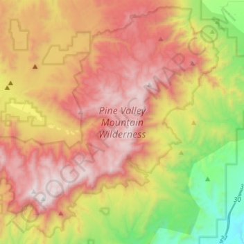
Mappa topografica Pine Valley Mountain Wilderness
Mappa interattiva
Clicca sulla mappa per visualizzare l'altitudine.
A proposito di questa mappa
Nome: Mappa topografica Pine Valley Mountain Wilderness, altitudine, rilievo.
Altitudine media: 2’125 m
Altitudine minima: 1’117 m
Altitudine massima: 3’147 m
Pine Valley Mountain Wilderness is a 50,232-acre (203.28 km2) wilderness area located in the Dixie National Forest in the U.S. state of Utah. It is the fourth-largest wilderness area located entirely within the state (following the High Uintas Wilderness, Zion Wilderness, and Cedar Mountain Wilderness). The wilderness designation protects the Pine Valley Mountain range, a large rock outcrop surrounded by desert. The Pine Valley Mountains form the Pine Valley Laccolith, one of the largest laccoliths in the United States. Elevations in the wilderness range from 6,000 feet (1,800 m) to 10,365 feet (3,159 m) at the summit of Signal Peak.
Altre mappe topografiche
Clicca su una mappa per visualizzarne la topografia, l'altitudine e il rilievo.
Springdale
United States > Utah > Washington County
Springdale, Washington County, Utah, 84767, United States
Altitudine media: 1’354 m
Saint George
United States > Utah > Washington County
Saint George, Washington County, Utah, United States
Altitudine media: 929 m
Cottonwood Canyon Wilderness
United States > Utah > Washington County > Washington
Cottonwood Canyon Wilderness, Washington, Washington County, Utah, United States
Altitudine media: 1’213 m
Toquerville
United States > Utah > Washington County
Toquerville, Washington County, Utah, 84774, United States
Altitudine media: 1’301 m
Hurricane
United States > Utah > Washington County
Hurricane, Washington County, Utah, United States
Altitudine media: 1’154 m
Ivins
United States > Utah > Washington County > Ivins
Ivins, Washington County, Utah, 84738, United States
Altitudine media: 1’007 m
Zion National Park
United States > Utah > Washington County
Zion National Park, Washington County, Utah, United States
Altitudine media: 1’877 m