
Fai una donazione
Equipaggiati per la tua prossima avventura:
In qualità di Affiliato Amazon, questo sito riceve una commissione sugli acquisti idonei, senza costi aggiuntivi per l’utente.
Mappa topografica Lascar
Clicca sulla mappa per visualizzare l'altitudine.
Fai una donazione
Equipaggiati per la tua prossima avventura:
In qualità di Affiliato Amazon, questo sito riceve una commissione sugli acquisti idonei, senza costi aggiuntivi per l’utente.
Lascar
Large lava flows are noticeable on the flanks of the volcano, with a total of eight lava flows recognized. They extend from the summit craters, although none of them appear to be associated with the currently active crater. Flows from the first stage of Lascar's activity are exposed at its western foot, while lava flows are buried beneath pyroclastic material on the eastern flank. A 6-kilometre-long (3.7 mi) lava flow on the northern flank reaches almost to the village of Talabre. This lava flow is known as the Tumbres–Talabre lava flow; its margins are 10–40 metres (33–131 ft) high, and it features a central channel. The flow advanced just north of the head of Quebrada Talabre before passing over cliffs and entering it. Another lava flow on the southwest flank is known as the Capricorn Lava. This dacitic lava was erupted on Lascar at high altitude and has a blocky surface. It features well developed levees and a 10-metre-thick (33 ft) flow front. Its rocks have a pale gray-blue colour, and their composition resembles the Soncor flow, despite more mafic lavas and pyroclastics being erupted in the time period between the emplacement of the Soncor flow and the Capricorn Lava.
Fai una donazione
Equipaggiati per la tua prossima avventura:
In qualità di Affiliato Amazon, questo sito riceve una commissione sugli acquisti idonei, senza costi aggiuntivi per l’utente.
A proposito di questa mappa
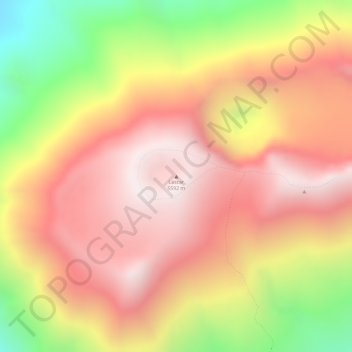
Nome: Mappa topografica Lascar, altitudine, rilievo.
Altitudine media: 5’269 m
Altitudine minima: 4’711 m
Altitudine massima: 5’600 m
Fai una donazione
Equipaggiati per la tua prossima avventura:
In qualità di Affiliato Amazon, questo sito riceve una commissione sugli acquisti idonei, senza costi aggiuntivi per l’utente.
Altre mappe topografiche
Clicca su una mappa per visualizzarne la topografia, l'altitudine e il rilievo.
Laguna Lejía
Chile > Antofagasta Region > Provincia de El Loa > San Pedro de Atacama
Lejía Lake is a circular, shallow lake at an elevation of 4,325 metres (14,190 ft) with a surface area of 1.9 square kilometres (0.73 sq mi) or 2 square kilometres (0.77 sq mi). It is a polymictic lake which freezes over occasionally and whose waters are turned over quickly, mainly through evaporation. Winds…
Altitudine media: 4’341 m