
Fai una donazione
Equipaggiati per la tua prossima avventura:
In qualità di Affiliato Amazon, questo sito riceve una commissione sugli acquisti idonei, senza costi aggiuntivi per l’utente.
Mappa topografica Upper Saucon
Clicca sulla mappa per visualizzare l'altitudine.
Fai una donazione
Equipaggiati per la tua prossima avventura:
In qualità di Affiliato Amazon, questo sito riceve una commissione sugli acquisti idonei, senza costi aggiuntivi per l’utente.
Upper Saucon
According to the U.S. Census Bureau, the township has a total area of 24.6 square miles (63.7 km2), of which 24.5 square miles (63.4 km2) are land and 0.2 square miles (0.4 km2), or 0.59%, are water. Its boundary with Salisbury Township is located on South Mountain. Elevations range from 340 feet (100 m) in Spring Valley to 1,042 feet (318 m) at Bauer Rock atop South Mountain in Big Rock County Park. Upper Saucon is in the Delaware River watershed and is drained by Saucon Creek into the Lehigh River, except for a very small area in the extreme south just southwest of Locust Valley, which is drained by Unami Creek into Perkiomen Creek and the Schuylkill River.
Fai una donazione
Equipaggiati per la tua prossima avventura:
In qualità di Affiliato Amazon, questo sito riceve una commissione sugli acquisti idonei, senza costi aggiuntivi per l’utente.
A proposito di questa mappa
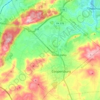
Nome: Mappa topografica Upper Saucon, altitudine, rilievo.
Luogo: Upper Saucon, Lehigh County, Pennsylvania, United States (40.48798 -75.47584 40.58115 -75.33305)
Altitudine media: 175 m
Altitudine minima: 77 m
Altitudine massima: 316 m
Fai una donazione
Equipaggiati per la tua prossima avventura:
In qualità di Affiliato Amazon, questo sito riceve una commissione sugli acquisti idonei, senza costi aggiuntivi per l’utente.
Altre mappe topografiche
Clicca su una mappa per visualizzarne la topografia, l'altitudine e il rilievo.
East Texas
United States > Pennsylvania > Lehigh County > Lower Macungie Township
Altitudine media: 126 m
Fogelsville
United States > Pennsylvania > Lehigh County > Upper Macungie Township
Altitudine media: 155 m
North Coplay
United States > Pennsylvania > Lehigh County > Whitehall > Cementon
Altitudine media: 116 m
Leather Corner Post
United States > Pennsylvania > Lehigh County > Lowhill Township
Altitudine media: 178 m
Fai una donazione
Equipaggiati per la tua prossima avventura:
In qualità di Affiliato Amazon, questo sito riceve una commissione sugli acquisti idonei, senza costi aggiuntivi per l’utente.
Centreville
United States > Pennsylvania > Lehigh County > Lower Macungie Township
Altitudine media: 144 m
Hillside
United States > Pennsylvania > Lehigh County > South Whitehall Township
Altitudine media: 152 m
South Mountain
United States > Pennsylvania > Lehigh County > Upper Saucon
Unlike Blue Mountain to its north, South Mountain does not follow a straight geographic line. The mountain ranges in elevation between 500 and 1,300 feet (150 and 400 m) above sea level. The ridge is made of metamorphic rocks and gneiss, which date to the Precambrian era and range from about 570 million to…
Altitudine media: 153 m
Fai una donazione
Equipaggiati per la tua prossima avventura:
In qualità di Affiliato Amazon, questo sito riceve una commissione sugli acquisti idonei, senza costi aggiuntivi per l’utente.
Limeport
United States > Pennsylvania > Lehigh County > Lower Milford Township
Altitudine media: 203 m
Orefield
United States > Pennsylvania > Lehigh County > North Whitehall Township
Altitudine media: 141 m
Wescosville
United States > Pennsylvania > Lehigh County > Lower Macungie Township
Altitudine media: 128 m
Fai una donazione
Equipaggiati per la tua prossima avventura:
In qualità di Affiliato Amazon, questo sito riceve una commissione sugli acquisti idonei, senza costi aggiuntivi per l’utente.
Fogelsville
United States > Pennsylvania > Lehigh County > Upper Macungie Township
Altitudine media: 155 m
Vera Cruz Station
United States > Pennsylvania > Lehigh County > Upper Milford Township
Altitudine media: 199 m
South Mountain
United States > Pennsylvania > Lehigh County > Upper Saucon
Unlike Blue Mountain to its north, South Mountain does not follow a straight geographic line. The mountain ranges in elevation between 500 and 1,300 feet (150 and 400 m) above sea level. The ridge is made of metamorphic rocks and gneiss, which date to the Precambrian era and range from about 570 million to…
Altitudine media: 153 m
Fai una donazione
Equipaggiati per la tua prossima avventura:
In qualità di Affiliato Amazon, questo sito riceve una commissione sugli acquisti idonei, senza costi aggiuntivi per l’utente.
Trexlertown
United States > Pennsylvania > Lehigh County > Upper Macungie Township
Trexlertown is located southwest of the center of Lehigh County along the southeastern edge of Upper Macungie Township at an altitude of 397 feet (121 m). It is bordered to the southwest by Breinigsville and to the southeast by Lower Macungie Township. U.S. Route 222 forms the northern edge of the community;…
Altitudine media: 127 m
Saegersville
United States > Pennsylvania > Lehigh County > Heidelberg Township
Altitudine media: 208 m
North Fogelsville
United States > Pennsylvania > Lehigh County > Upper Macungie Township > Fogelsville
Altitudine media: 165 m
Kernsville
United States > Pennsylvania > Lehigh County > North Whitehall Township
Altitudine media: 147 m
Fai una donazione
Equipaggiati per la tua prossima avventura:
In qualità di Affiliato Amazon, questo sito riceve una commissione sugli acquisti idonei, senza costi aggiuntivi per l’utente.
Ironton
United States > Pennsylvania > Lehigh County > North Whitehall Township
Altitudine media: 158 m
Leather Corner Post
United States > Pennsylvania > Lehigh County > Lowhill Township
Altitudine media: 178 m
Orefield
United States > Pennsylvania > Lehigh County > North Whitehall Township
Altitudine media: 141 m
Fai una donazione
Equipaggiati per la tua prossima avventura:
In qualità di Affiliato Amazon, questo sito riceve una commissione sugli acquisti idonei, senza costi aggiuntivi per l’utente.
Weilersville
United States > Pennsylvania > Lehigh County > Lower Macungie Township
Altitudine media: 126 m
Jordan Valley
United States > Pennsylvania > Lehigh County > Heidelberg Township
Altitudine media: 213 m
Cherry Hill
United States > Pennsylvania > Lehigh County > Upper Macungie Township
Altitudine media: 146 m
Weidasville
United States > Pennsylvania > Lehigh County > Lowhill Township > Weidasville
Altitudine media: 170 m
Fai una donazione
Equipaggiati per la tua prossima avventura:
In qualità di Affiliato Amazon, questo sito riceve una commissione sugli acquisti idonei, senza costi aggiuntivi per l’utente.
Crackersport
United States > Pennsylvania > Lehigh County > South Whitehall Township
Altitudine media: 138 m
Ormrod
United States > Pennsylvania > Lehigh County > North Whitehall Township
Altitudine media: 148 m