
Fai una donazione
Equipaggiati per la tua prossima avventura:
In qualità di Affiliato Amazon, questo sito riceve una commissione sugli acquisti idonei, senza costi aggiuntivi per l’utente.
Mappa topografica Mount Kenya
Clicca sulla mappa per visualizzare l'altitudine.
Fai una donazione
Equipaggiati per la tua prossima avventura:
In qualità di Affiliato Amazon, questo sito riceve una commissione sugli acquisti idonei, senza costi aggiuntivi per l’utente.
Mount Kenya
The mountain's lower slopes, which have never been glaciated, are currently dominated by a mix of cultivation and forest, and are characterized by deep, fluvial V-shaped valleys with numerous branching tributaries. In contrast, the higher elevations of the moorland zone feature shallower, flat-bottomed U-shaped valleys carved by ancient glacial activity. This stark topographical shift marks the transition from landscapes shaped by millions of years of river erosion to those sculpted by the movement of prehistoric ice sheets.
Fai una donazione
Equipaggiati per la tua prossima avventura:
In qualità di Affiliato Amazon, questo sito riceve una commissione sugli acquisti idonei, senza costi aggiuntivi per l’utente.
A proposito di questa mappa
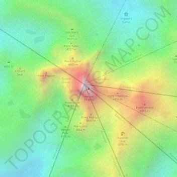
Nome: Mappa topografica Mount Kenya, altitudine, rilievo.
Luogo: Mount Kenya, Manyatta, Embu, Kenya (-0.15276 37.30916 -0.15266 37.30926)
Altitudine media: 4’556 m
Altitudine minima: 4’181 m
Altitudine massima: 5’149 m
Fai una donazione
Equipaggiati per la tua prossima avventura:
In qualità di Affiliato Amazon, questo sito riceve una commissione sugli acquisti idonei, senza costi aggiuntivi per l’utente.
Altre mappe topografiche
Clicca su una mappa per visualizzarne la topografia, l'altitudine e il rilievo.
Embu
The Municipality of Embu has an elevation of 1,350 metres (4,429 ft), and is located on the foothills of Mount Kenya. It was the provincial headquarters of the defunct Eastern province, and is currently the Embu County Headquarters, hosting major public offices and institutions, including Embu Provincial…
Altitudine media: 1’352 m