
Fai una donazione
Equipaggiati per la tua prossima avventura:
In qualità di Affiliato Amazon, questo sito riceve una commissione sugli acquisti idonei, senza costi aggiuntivi per l’utente.
Mappa topografica Arthursburg
Clicca sulla mappa per visualizzare l'altitudine.
Fai una donazione
Equipaggiati per la tua prossima avventura:
In qualità di Affiliato Amazon, questo sito riceve una commissione sugli acquisti idonei, senza costi aggiuntivi per l’utente.
A proposito di questa mappa
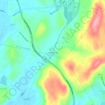
Nome: Mappa topografica Arthursburg, altitudine, rilievo.
Altitudine media: 130 m
Altitudine minima: 89 m
Altitudine massima: 216 m
Fai una donazione
Equipaggiati per la tua prossima avventura:
In qualità di Affiliato Amazon, questo sito riceve una commissione sugli acquisti idonei, senza costi aggiuntivi per l’utente.
Altre mappe topografiche
Clicca su una mappa per visualizzarne la topografia, l'altitudine e il rilievo.
Town of Pawling
United States > New York > Dutchess County
The eastern and western section of the towns are high and hilly, with the Great Swamp and Harlem Valley in the middle, where the village of Pawling is located. The highest elevation in town is Observatory Hill, at 1,332 feet (406 m) above sea level; the lowest is 420 feet (130 m), in the Great Swamp, along the…
Altitudine media: 243 m
Hillside Lake
United States > New York > Dutchess County > Town of East Fishkill > Hillside Lake
Altitudine media: 103 m
Fai una donazione
Equipaggiati per la tua prossima avventura:
In qualità di Affiliato Amazon, questo sito riceve una commissione sugli acquisti idonei, senza costi aggiuntivi per l’utente.
Fai una donazione
Equipaggiati per la tua prossima avventura:
In qualità di Affiliato Amazon, questo sito riceve una commissione sugli acquisti idonei, senza costi aggiuntivi per l’utente.
Town of North East
United States > New York > Dutchess County
Brace Mountain's 2,311-foot (704 m) summit, near the Connecticut state line in the northeastern corner of town, is the highest point in Dutchess County. The lowest elevation is 530 feet (160 m), along Shekomeko Creek at the Pine Plains town line.
Altitudine media: 267 m
Fai una donazione
Equipaggiati per la tua prossima avventura:
In qualità di Affiliato Amazon, questo sito riceve una commissione sugli acquisti idonei, senza costi aggiuntivi per l’utente.
Dover Plains
United States > New York > Dutchess County > Dover Plains > Bains Corner
Altitudine media: 149 m
Staatsburg
United States > New York > Dutchess County > Town of Hyde Park > Staatsburg
Altitudine media: 25 m
City of Poughkeepsie
United States > New York > Dutchess County
According to the United States Census Bureau, the city has an area of 5.7 square miles (14.8 km2), of which 5.1 square miles (13.3 km2) is land, and 0.23 square miles (0.6 km2) (comprising 10.05%) is water. Poughkeepsie lies approximately 75 miles (121 km) north of the center of the New York megacity. It is…
Altitudine media: 49 m
Fai una donazione
Equipaggiati per la tua prossima avventura:
In qualità di Affiliato Amazon, questo sito riceve una commissione sugli acquisti idonei, senza costi aggiuntivi per l’utente.
Hydepark Recreations
United States > New York > Dutchess County > Town of Hyde Park
Altitudine media: 66 m
Fai una donazione
Equipaggiati per la tua prossima avventura:
In qualità di Affiliato Amazon, questo sito riceve una commissione sugli acquisti idonei, senza costi aggiuntivi per l’utente.
Town of Fishkill
United States > New York > Dutchess County
According to the United States Census Bureau, the town has a total area of 32.0 square miles (82.9 km2), of which 27.3 square miles (70.8 km2) is land and 4.7 square miles (12.1 km2), or 14.55%, is water. The elevation of the town varies from sea level along the Hudson River (Fishkill Waterfront, Fishkill…
Altitudine media: 178 m
Fai una donazione
Equipaggiati per la tua prossima avventura:
In qualità di Affiliato Amazon, questo sito riceve una commissione sugli acquisti idonei, senza costi aggiuntivi per l’utente.
Hopewell Junction
United States > New York > Dutchess County > Town of East Fishkill > Hopewell Junction
Altitudine media: 83 m
Fai una donazione
Equipaggiati per la tua prossima avventura:
In qualità di Affiliato Amazon, questo sito riceve una commissione sugli acquisti idonei, senza costi aggiuntivi per l’utente.
Fai una donazione
Equipaggiati per la tua prossima avventura:
In qualità di Affiliato Amazon, questo sito riceve una commissione sugli acquisti idonei, senza costi aggiuntivi per l’utente.
City of Poughkeepsie
United States > New York > Dutchess County
According to the United States Census Bureau, the city has an area of 5.7 square miles (14.8 km2), of which 5.1 square miles (13.3 km2) is land, and 0.23 square miles (0.6 km2) (comprising 10.05%) is water. Poughkeepsie lies approximately 75 miles (121 km) north of the center of the New York megacity. It is…
Altitudine media: 49 m
Fai una donazione
Equipaggiati per la tua prossima avventura:
In qualità di Affiliato Amazon, questo sito riceve una commissione sugli acquisti idonei, senza costi aggiuntivi per l’utente.
Town of Pawling
United States > New York > Dutchess County
The eastern and western section of the towns are high and hilly, with the Great Swamp and Harlem Valley in the middle, where the village of Pawling is located. The highest elevation in town is Observatory Hill, at 1,332 feet (406 m) above sea level; the lowest is 420 feet (130 m), in the Great Swamp, along the…
Altitudine media: 243 m
Fai una donazione
Equipaggiati per la tua prossima avventura:
In qualità di Affiliato Amazon, questo sito riceve una commissione sugli acquisti idonei, senza costi aggiuntivi per l’utente.
Town of Fishkill
United States > New York > Dutchess County
According to the United States Census Bureau, the town has a total area of 32.0 square miles (82.9 km2), of which 27.3 square miles (70.8 km2) is land and 4.7 square miles (12.1 km2), or 14.55%, is water. The elevation of the town varies from sea level along the Hudson River (Fishkill Waterfront, Fishkill…
Altitudine media: 178 m
Fai una donazione
Equipaggiati per la tua prossima avventura:
In qualità di Affiliato Amazon, questo sito riceve una commissione sugli acquisti idonei, senza costi aggiuntivi per l’utente.
Village of Red Hook
United States > New York > Dutchess County > Town of Red Hook
Altitudine media: 66 m
Fai una donazione
Equipaggiati per la tua prossima avventura:
In qualità di Affiliato Amazon, questo sito riceve una commissione sugli acquisti idonei, senza costi aggiuntivi per l’utente.
Rhinecliff
United States > New York > Dutchess County > Town of Rhinebeck
The hamlet is demarcated by large agricultural and wooded area to the north, east, and south, and bounded by the Hudson River on the west. Steep topography, formed by contorted slate ridges and valleys, define the site-specific and seemingly random orientation of the small, frame nineteenth-century houses and…
Altitudine media: 19 m
Hopewell Junction
United States > New York > Dutchess County > Town of East Fishkill > Hopewell Junction
Altitudine media: 83 m
Fai una donazione
Equipaggiati per la tua prossima avventura:
In qualità di Affiliato Amazon, questo sito riceve una commissione sugli acquisti idonei, senza costi aggiuntivi per l’utente.
Barrytown
United States > New York > Dutchess County > Town of Red Hook > Barrytown
Altitudine media: 26 m
Fai una donazione
Equipaggiati per la tua prossima avventura:
In qualità di Affiliato Amazon, questo sito riceve una commissione sugli acquisti idonei, senza costi aggiuntivi per l’utente.
Town of North East
United States > New York > Dutchess County
Brace Mountain's 2,311-foot (704 m) summit, near the Connecticut state line in the northeastern corner of town, is the highest point in Dutchess County. The lowest elevation is 530 feet (160 m), along Shekomeko Creek at the Pine Plains town line.
Altitudine media: 267 m