
Mappa topografica Forest of Dean
Mappa interattiva
Clicca sulla mappa per visualizzare l'altitudine.
A proposito di questa mappa
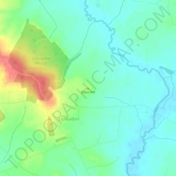
Nome: Mappa topografica Forest of Dean, altitudine, rilievo.
Altitudine media: 32 m
Altitudine minima: 12 m
Altitudine massima: 80 m
Altre mappe topografiche
Clicca su una mappa per visualizzarne la topografia, l'altitudine e il rilievo.
Fossil Beach
United Kingdom > England > Gloucestershire > Forest of Dean > Sedbury
Fossil Beach, Tidenham, Sedbury, Forest of Dean, Gloucestershire, England, NP16 7FD, United Kingdom
Altitudine media: 14 m
Kings Barton
United Kingdom > England > Gloucestershire > Gloucester
Kings Barton, Gloucester, Gloucestershire, England, GL1 1QT, United Kingdom
Altitudine media: 20 m
Moreton-in-Marsh
United Kingdom > England > Gloucestershire > Cotswold District
Moreton-in-Marsh, Cotswold District, Gloucestershire, England, United Kingdom
Altitudine media: 135 m
Prestbury
United Kingdom > England > Gloucestershire > Cheltenham
Prestbury, Cheltenham, Gloucestershire, England, GL52 3EL, United Kingdom
Altitudine media: 110 m
Upper Soudley
United Kingdom > England > Gloucestershire > Forest of Dean
Upper Soudley, Forest of Dean, Gloucestershire, England, GL14 2TS, United Kingdom
Altitudine media: 138 m
Hucclecote Green
United Kingdom > England > Gloucestershire > Gloucester
Hucclecote Green, Gloucester, Gloucestershire, England, GL3 3RB, United Kingdom
Altitudine media: 53 m
Tewkesbury
United Kingdom > England > Gloucestershire > Tewkesbury
Tewkesbury, Gloucestershire, England, United Kingdom
Altitudine media: 18 m
Strand
United Kingdom > England > Gloucestershire > Forest of Dean > Westbury-on-Severn
Strand, Westbury-on-Severn, Forest of Dean, Gloucestershire, England, GL14 1PG, United Kingdom
Altitudine media: 14 m
Shadwell
United Kingdom > England > Gloucestershire > Stroud > Uley
Shadwell, Uley, Stroud, Gloucestershire, England, GL11 5BW, United Kingdom
Altitudine media: 165 m
Blockley
United Kingdom > England > Gloucestershire > Cotswold District
Blockley, Cotswold District, Gloucestershire, England, United Kingdom
Altitudine media: 163 m
Taylors Hill
United Kingdom > England > Gloucestershire > Cotswold District
Taylors Hill, Cotswold District, Gloucestershire, England, GL54 4BJ, United Kingdom
Altitudine media: 237 m
Cirencester
United Kingdom > England > Gloucestershire > Cotswold District > Cirencester
Cirencester, Cotswold District, Gloucestershire, England, United Kingdom
Altitudine media: 128 m
Stonehouse
United Kingdom > England > Gloucestershire > Stonehouse
Stonehouse, Stroud, Gloucestershire, South West England, England, GL10 2, United Kingdom
Altitudine media: 75 m
The Noose
United Kingdom > England > Gloucestershire > Forest of Dean > Awre
The Noose, Awre, Forest of Dean, Gloucestershire, South West England, England, GL14 1, United Kingdom
Altitudine media: 5 m
Gloucester
United Kingdom > England > Gloucestershire
Gloucester, Gloucestershire, England, United Kingdom
Altitudine media: 36 m
Stroud
United Kingdom > England > Gloucestershire
Stroud, Gloucestershire, England, United Kingdom
Altitudine media: 113 m
Prestbury
United Kingdom > England > Gloucestershire > Cheltenham
Prestbury, Cheltenham, Gloucestershire, England, United Kingdom
Altitudine media: 63 m
Cheltenham
United Kingdom > England > Gloucestershire
Cheltenham, Gloucestershire, England, United Kingdom
Altitudine media: 109 m