
Fai una donazione
Equipaggiati per la tua prossima avventura:
In qualità di Affiliato Amazon, questo sito riceve una commissione sugli acquisti idonei, senza costi aggiuntivi per l’utente.
Mappa topografica Prospect
Clicca sulla mappa per visualizzare l'altitudine.
Fai una donazione
Equipaggiati per la tua prossima avventura:
In qualità di Affiliato Amazon, questo sito riceve una commissione sugli acquisti idonei, senza costi aggiuntivi per l’utente.
A proposito di questa mappa
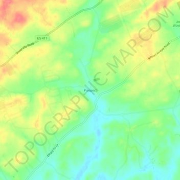
Nome: Mappa topografica Prospect, altitudine, rilievo.
Altitudine media: 304 m
Altitudine minima: 275 m
Altitudine massima: 340 m
Fai una donazione
Equipaggiati per la tua prossima avventura:
In qualità di Affiliato Amazon, questo sito riceve una commissione sugli acquisti idonei, senza costi aggiuntivi per l’utente.
Altre mappe topografiche
Clicca su una mappa per visualizzarne la topografia, l'altitudine e il rilievo.
Townsend
United States > Tennessee > Blount County
Just to the north and west of Townsend, the Foothills Parkway is a national parkway that traverses Chilhowee Mountain and offers multiple scenic overlooks at high elevations, with views of the Smokies to the south and the Tennessee Valley and Cumberland Plateau to the north and west. As of 2016, road…
Altitudine media: 376 m
Friendsville
United States > Tennessee > Blount County
Friendsville is located in western Blount County. The town is situated along State Route 333 (Miser Station Road) and stretches from Fort Loudoun Lake in the north to U.S. Route 321 (Lamar Alexander Parkway). It lies at an elevation of 879 feet (268 m).
Altitudine media: 280 m
Fai una donazione
Equipaggiati per la tua prossima avventura:
In qualità di Affiliato Amazon, questo sito riceve una commissione sugli acquisti idonei, senza costi aggiuntivi per l’utente.