
Mappa topografica Bir
Clicca sulla mappa per visualizzare l'altitudine.
Bir
The paragliding launch site is in the meadow at Billing (14 km north of Bir), at an elevation of 2400 meters, while the landing site and most tourist accommodations are in the village of Chowgan (also spelled Chaugan), on the southern edge of Bir.
A proposito di questa mappa
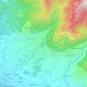
Nome: Mappa topografica Bir, altitudine, rilievo.
Luogo: Bir, Baijnath, Kangra, Himachal Pradesh, 176077, India (32.02452 76.70551 32.06452 76.74551)
Altitudine media: 1’628 m
Altitudine minima: 1’284 m
Altitudine massima: 2’560 m