
Fai una donazione
Equipaggiati per la tua prossima avventura:
In qualità di Affiliato Amazon, questo sito riceve una commissione sugli acquisti idonei, senza costi aggiuntivi per l’utente.
Mappa topografica Mountain Top
Clicca sulla mappa per visualizzare l'altitudine.
Fai una donazione
Equipaggiati per la tua prossima avventura:
In qualità di Affiliato Amazon, questo sito riceve una commissione sugli acquisti idonei, senza costi aggiuntivi per l’utente.
Mountain Top
The elevation within the Mountain Top CDP ranges from 1,070 feet (330 m) above sea level along Big Wapwallopen Creek in the southwest, to 1,860 feet (570 m) atop Nescopeck Mountain southwest of Rita, to 1,871 feet (570 m) at the east end of Penobscot Mountain in the north of the CDP. The central village of Mountain Top sits at 1,580 feet (480 m) just south of Penobscot Mountain.
Fai una donazione
Equipaggiati per la tua prossima avventura:
In qualità di Affiliato Amazon, questo sito riceve una commissione sugli acquisti idonei, senza costi aggiuntivi per l’utente.
A proposito di questa mappa
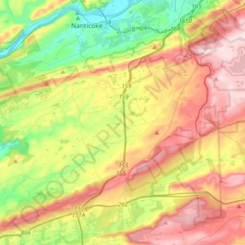
Nome: Mappa topografica Mountain Top, altitudine, rilievo.
Altitudine media: 463 m
Altitudine minima: 300 m
Altitudine massima: 646 m
Fai una donazione
Equipaggiati per la tua prossima avventura:
In qualità di Affiliato Amazon, questo sito riceve una commissione sugli acquisti idonei, senza costi aggiuntivi per l’utente.
Altre mappe topografiche
Clicca su una mappa per visualizzarne la topografia, l'altitudine e il rilievo.