
Fai una donazione
Equipaggiati per la tua prossima avventura:
In qualità di Affiliato Amazon, questo sito riceve una commissione sugli acquisti idonei, senza costi aggiuntivi per l’utente.
Mappa topografica Eastham Village
Clicca sulla mappa per visualizzare l'altitudine.
Fai una donazione
Equipaggiati per la tua prossima avventura:
In qualità di Affiliato Amazon, questo sito riceve una commissione sugli acquisti idonei, senza costi aggiuntivi per l’utente.
A proposito di questa mappa
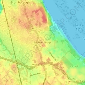
Nome: Mappa topografica Eastham Village, altitudine, rilievo.
Altitudine media: 24 m
Altitudine minima: 0 m
Altitudine massima: 48 m
Fai una donazione
Equipaggiati per la tua prossima avventura:
In qualità di Affiliato Amazon, questo sito riceve una commissione sugli acquisti idonei, senza costi aggiuntivi per l’utente.
Altre mappe topografiche
Clicca su una mappa per visualizzarne la topografia, l'altitudine e il rilievo.
Sheffield
Sheffield nestles on the eastern foothills of the Pennines and is sculpted by a dramatic hill-and-valley system formed where five rivers — the Don, Sheaf, Rivelin, Loxley and Porter — converge, producing steep-sided valleys and gritstone ridgelines with much of the urban area built directly onto hillsides…
Altitudine media: 168 m
Bath
United Kingdom > England > Bath and North East Somerset
Bath is in the Avon Valley and is surrounded by limestone hills as it is near the southern edge of the Cotswolds, a designated Area of Outstanding Natural Beauty, and the limestone Mendip Hills rise around 7 miles (11 km) south of the city. The hills that surround and make up the city have a maximum altitude…
Altitudine media: 100 m
Fai una donazione
Equipaggiati per la tua prossima avventura:
In qualità di Affiliato Amazon, questo sito riceve una commissione sugli acquisti idonei, senza costi aggiuntivi per l’utente.
South East England
Near Weybridge are the UK headquarters of Sony with SSP Group (situated in Byfleet) and Procter & Gamble (next door to each other on The Heights Business Park near the former Brooklands racing circuit) with Kia Motors UK and Petroleum Geo-Services UK, and Gallaher Group (cigarettes) is to the north, next to…
Altitudine media: 69 m
Fai una donazione
Equipaggiati per la tua prossima avventura:
In qualità di Affiliato Amazon, questo sito riceve una commissione sugli acquisti idonei, senza costi aggiuntivi per l’utente.
Dartmoor National Park
United Kingdom > England > Devon
Rainfall tends to be associated with Atlantic depressions or with convection. In summer, convection caused by solar surface heating sometimes forms shower clouds and a large proportion of rainfall falls from showers and thunderstorms at this time of year. The wettest months are November and December and on the…
Altitudine media: 239 m
Hertfordshire
Elevations are higher in the north and west, reaching more than 800 feet (240 m) in the Chilterns near Tring. The county centres on the headwaters and upper valleys of the rivers Lea and the Colne; both flow south, and each is accompanied by a canal. Hertfordshire's undeveloped land is mainly agricultural,…
Altitudine media: 82 m
Birmingham
Birmingham is a snowy city relative to other large UK conurbations, due to its inland location and comparatively high elevation. Between 1961 and 1990 Birmingham Airport averaged 13.0 days of snow lying annually, compared to 5.33 at London Heathrow. Snow showers often pass through the city via the Cheshire gap…
Altitudine media: 138 m
Fai una donazione
Equipaggiati per la tua prossima avventura:
In qualità di Affiliato Amazon, questo sito riceve una commissione sugli acquisti idonei, senza costi aggiuntivi per l’utente.
Cambridge
United Kingdom > England > Cambridge
The city, like most of the UK, has a maritime climate highly influenced by the Gulf Stream. Located in the driest region of Britain, Cambridge's rainfall averages around 570 mm (22.44 in) per year, around half the national average, with some years occasionally falling into the semi-arid (under 500 mm (19.69…
Altitudine media: 18 m
Lake District National Park
The Lake District is a roughly circular upland massif, deeply dissected by a broadly radial pattern of major valleys which are largely the result of repeated glaciations over the last 2 million years. The apparent radial pattern is not from a central dome, but from an axial watershed extending from St Bees…
Altitudine media: 206 m
Kent
Kent was also the location of the largest number of art schools in the country during the nineteenth century, estimated by the art historian David Haste, to approach two hundred. This is believed to be the result of Kent being a front line county during the Napoleonic Wars. At this time, before the invention…
Altitudine media: 37 m
Fai una donazione
Equipaggiati per la tua prossima avventura:
In qualità di Affiliato Amazon, questo sito riceve una commissione sugli acquisti idonei, senza costi aggiuntivi per l’utente.
Cambridgeshire
Cambridgeshire has a maritime temperate climate which is broadly similar to the rest of the United Kingdom, though it is drier than the UK average due to its low altitude and easterly location, the prevailing southwesterly winds having already deposited moisture on higher ground further west. Average winter…
Altitudine media: 32 m
Yorkshire
In Yorkshire there is a very close relationship between the major topographical areas and the geological period in which they were formed. The Pennine chain of hills in the west is of Carboniferous origin. The central vale is Permo-Triassic. The North York Moors in the north-east of the county are Jurassic in…
Altitudine media: 130 m
East Riding of Yorkshire
The western part of the district in the Vale of York borders on and is drained by the River Derwent. The landscape is generally low-lying and flat although minor ridges and glacial moraines provide some variations in topography. Where there are dry sandy soils there are remnants of historic heathlands and…
Altitudine media: 30 m
Fai una donazione
Equipaggiati per la tua prossima avventura:
In qualità di Affiliato Amazon, questo sito riceve una commissione sugli acquisti idonei, senza costi aggiuntivi per l’utente.
Cornwall
The interior of the county consists of a roughly east–west spine of infertile and exposed upland, with a series of granite intrusions, such as Bodmin Moor, which contains the highest land within Cornwall. From east to west, and with approximately descending altitude, these are Bodmin Moor, Hensbarrow north…
Altitudine media: 55 m
Fai una donazione
Equipaggiati per la tua prossima avventura:
In qualità di Affiliato Amazon, questo sito riceve una commissione sugli acquisti idonei, senza costi aggiuntivi per l’utente.
Fai una donazione
Equipaggiati per la tua prossima avventura:
In qualità di Affiliato Amazon, questo sito riceve una commissione sugli acquisti idonei, senza costi aggiuntivi per l’utente.
East of England
The East of England region has the lowest elevation range in the UK. Twenty percent of the region is below mean sea level, most of this in North Cambridgeshire, Norfolk and on the Essex Coast. Most of the remaining area is of low elevation, with extensive glacial deposits. The Fens, a large area of reclaimed…
Altitudine media: 39 m
North East England
North East England has a Marine west coast climate (generally found along the west coast of middle latitude continents) with narrower temperature ranges than the south of England and sufficient precipitation in all months. Summers and winters are mild rather than extremely hot or cold, due to the strong…
Altitudine media: 165 m
Fai una donazione
Equipaggiati per la tua prossima avventura:
In qualità di Affiliato Amazon, questo sito riceve una commissione sugli acquisti idonei, senza costi aggiuntivi per l’utente.
Exeter
United Kingdom > England > Devon
The city of Exeter was established on the eastern bank of the River Exe on a ridge of land backed by a steep hill. It is at this point that the Exe, having just been joined by the River Creedy, opens onto a wide flood plain and estuary which results in quite common flooding. Historically this was the lowest…
Altitudine media: 56 m
Fai una donazione
Equipaggiati per la tua prossima avventura:
In qualità di Affiliato Amazon, questo sito riceve una commissione sugli acquisti idonei, senza costi aggiuntivi per l’utente.
Buxton
United Kingdom > England > Derbyshire > High Peak
Buxton has an oceanic climate with short, mild summers and long, cool winters. At about 1,000 feet (300 m) above sea level, As the highest market town in England, Buxton's elevation makes it cooler and wetter than surrounding towns, with a daytime temperature typically about 2 °C lower than Manchester.
Altitudine media: 334 m
Fai una donazione
Equipaggiati per la tua prossima avventura:
In qualità di Affiliato Amazon, questo sito riceve una commissione sugli acquisti idonei, senza costi aggiuntivi per l’utente.
Suffolk
The west of the county lies on more resistant Cretaceous chalk. This chalk is responsible for a sweeping tract of largely downland landscapes that stretches from Dorset in the south west to Dover in the south east and north through East Anglia to the Yorkshire Wolds. The chalk is less easily eroded so forms…
Altitudine media: 35 m
Lincoln
United Kingdom > England > Lincolnshire
Lincoln lies 157 mi (253 km) north of London, at an altitude of 67 ft (20.4 m) by the River Witham up to 246 ft (75.0 m) on Castle Hill. It fills a gap in the Lincoln Cliff escarpment, which runs north and south through central Lincolnshire, with altitudes up to 200 feet (61 metres). The city lies on the River…
Altitudine media: 29 m
Fai una donazione
Equipaggiati per la tua prossima avventura:
In qualità di Affiliato Amazon, questo sito riceve una commissione sugli acquisti idonei, senza costi aggiuntivi per l’utente.
Malmesbury
United Kingdom > England > Wiltshire
Malmesbury sits on a flat Cotswolds hilltop at the convergence of two rivers. The town has a maximum elevation of 146 metres (479 ft) and a minimum of 56 metres (184 ft); the average elevation is 92 metres (302 ft) above sea level. From the west, the infant (Bristol) Avon flows from Sherston, and from the…
Altitudine media: 84 m
Northill
United Kingdom > England > Central Bedfordshire
Topographically, Northill stands on a slightly elevated ridge that runs north to south. The village lies on the border of the Bedfordshire and Cambridgeshire Claylands and the Bedfordshire Greensand Ridge; National Character Areas designated by Natural England. Central Bedfordshire Council has classified the…
Altitudine media: 37 m
Fai una donazione
Equipaggiati per la tua prossima avventura:
In qualità di Affiliato Amazon, questo sito riceve una commissione sugli acquisti idonei, senza costi aggiuntivi per l’utente.
Plymouth
The River Plym, which flows off Dartmoor to the north-east, forms a smaller estuary to the east of the city called Cattewater. Plymouth Sound is protected from the sea by the Plymouth Breakwater, in use since 1814. In the Sound is Drake's Island which is seen from Plymouth Hoe, a flat public area on top of…
Altitudine media: 46 m
Fai una donazione
Equipaggiati per la tua prossima avventura:
In qualità di Affiliato Amazon, questo sito riceve una commissione sugli acquisti idonei, senza costi aggiuntivi per l’utente.
Greater London
London's topography is characterized by a gently rolling terrain shaped by the River Thames and its tributaries. The city lies within the London Basin, a natural depression bordered by higher grounds such as the North Downs to the south and the Chiltern Hills to the northwest. The Thames flows west to east,…
Altitudine media: 66 m
River Tees
The source of the river at Teeshead just below Cross Fell is at an elevation of about 2,401 feet (732 m). It flows east-north-east through an area of shake holes through Carboniferous Limestone. Below Viewing Hill, it turns south to the Cow Green Reservoir constructed to store water to be released in dry…
Altitudine media: 218 m
Fai una donazione
Equipaggiati per la tua prossima avventura:
In qualità di Affiliato Amazon, questo sito riceve una commissione sugli acquisti idonei, senza costi aggiuntivi per l’utente.
Derbyshire
Due to its central location in England and altitude range from 27 metres in the south to 636 metres in the north, Derbyshire contains many species at the edge of their UK distribution ranges. Some species with a predominantly northern British distribution are at the southern limit of their range, whilst others…
Altitudine media: 144 m
Fai una donazione
Equipaggiati per la tua prossima avventura:
In qualità di Affiliato Amazon, questo sito riceve una commissione sugli acquisti idonei, senza costi aggiuntivi per l’utente.
Basingstoke
United Kingdom > England > Hampshire > Basingstoke and Deane
Situated in a valley through the Hampshire Downs at an average elevation of 88 metres (289 ft) Basingstoke is a major interchange between Reading, Newbury, Andover, Winchester, and Alton, and lies on the natural trade route between the southwest of England and London. The area had been something of an…
Altitudine media: 109 m
Fai una donazione
Equipaggiati per la tua prossima avventura:
In qualità di Affiliato Amazon, questo sito riceve una commissione sugli acquisti idonei, senza costi aggiuntivi per l’utente.
Borough of Luton
The local climate around Luton is differentiated somewhat from much of South East England due to its position in the Chiltern Hills, meaning it tends to be 1–2 degrees Celsius cooler than the surrounding towns – often flights at Luton airport, lying 160 m (525 ft) above sea level, will be suspended when…
Altitudine media: 146 m
Fai una donazione
Equipaggiati per la tua prossima avventura:
In qualità di Affiliato Amazon, questo sito riceve una commissione sugli acquisti idonei, senza costi aggiuntivi per l’utente.
Fai una donazione
Equipaggiati per la tua prossima avventura:
In qualità di Affiliato Amazon, questo sito riceve una commissione sugli acquisti idonei, senza costi aggiuntivi per l’utente.
South Downs National Park
United Kingdom > England > West Sussex
The South Downs National Park's chalk downland is a feature that sets it apart from other national parks in Britain. However, almost a quarter (23%) of the national park consists of a quite different and strongly contrasting physiographic region, the western Weald, whose densely wooded hills and vales are…
Altitudine media: 54 m
Fai una donazione
Equipaggiati per la tua prossima avventura:
In qualità di Affiliato Amazon, questo sito riceve una commissione sugli acquisti idonei, senza costi aggiuntivi per l’utente.
Fai una donazione
Equipaggiati per la tua prossima avventura:
In qualità di Affiliato Amazon, questo sito riceve una commissione sugli acquisti idonei, senza costi aggiuntivi per l’utente.
Fai una donazione
Equipaggiati per la tua prossima avventura:
In qualità di Affiliato Amazon, questo sito riceve una commissione sugli acquisti idonei, senza costi aggiuntivi per l’utente.
Connaught Water
United Kingdom > England > Essex > Epping Forest > Sewardstonebury
Altitudine media: 57 m
Fai una donazione
Equipaggiati per la tua prossima avventura:
In qualità di Affiliato Amazon, questo sito riceve una commissione sugli acquisti idonei, senza costi aggiuntivi per l’utente.
Reading
Jane Austen attended Reading Ladies Boarding School, based in the Abbey Gateway, in 1784–1786. Mary Russell Mitford lived in Reading for a number of years and then spent the rest of her life just outside the town at Three Mile Cross and Swallowfield. The fictional Belford Regis of her eponymous novel, first…
Altitudine media: 54 m
Leicestershire
A large part of the north-west of the county, around Coalville, forms part of the new National Forest area extending into Derbyshire and Staffordshire. The highest point of the county is Bardon Hill at 278 m (912 ft), which is also a Marilyn; with other hilly/upland areas of around 150–200 metres (490–660…
Altitudine media: 97 m
Fai una donazione
Equipaggiati per la tua prossima avventura:
In qualità di Affiliato Amazon, questo sito riceve una commissione sugli acquisti idonei, senza costi aggiuntivi per l’utente.
City of Westminster
The area was historically part of the county of Middlesex. Whilst an important centre of royal authority from Saxon times, Westminster was not formally incorporated as a borough for local government purposes until 1900. However, it was declared a city in 1540 on the elevation of Westminster Abbey to being a…
Altitudine media: 23 m
Fai una donazione
Equipaggiati per la tua prossima avventura:
In qualità di Affiliato Amazon, questo sito riceve una commissione sugli acquisti idonei, senza costi aggiuntivi per l’utente.
Chedworth
United Kingdom > England > Gloucestershire > Cotswold District > Chedworth
Altitudine media: 187 m
Fai una donazione
Equipaggiati per la tua prossima avventura:
In qualità di Affiliato Amazon, questo sito riceve una commissione sugli acquisti idonei, senza costi aggiuntivi per l’utente.