
Fai una donazione
Equipaggiati per la tua prossima avventura:
In qualità di Affiliato Amazon, questo sito riceve una commissione sugli acquisti idonei, senza costi aggiuntivi per l’utente.
Mappa topografica Norfolk
Clicca sulla mappa per visualizzare l'altitudine.
Fai una donazione
Equipaggiati per la tua prossima avventura:
In qualità di Affiliato Amazon, questo sito riceve una commissione sugli acquisti idonei, senza costi aggiuntivi per l’utente.
Norfolk
According to the United States Census Bureau, the town has a total area of 46.4 square miles (120.2 km2), of which 45.3 square miles (117.4 km2) are land and 1.1 square miles (2.9 km2), or 2.38%, are water. The town is located in the Litchfield Hills portion of the Appalachian mountain range. Norfolk's elevation is 1,230 feet (370 m) above sea level, and the town is sometimes called "the Icebox of Connecticut" for its severe winters and particularly cool summers.
Fai una donazione
Equipaggiati per la tua prossima avventura:
In qualità di Affiliato Amazon, questo sito riceve una commissione sugli acquisti idonei, senza costi aggiuntivi per l’utente.
A proposito di questa mappa
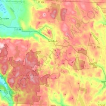
Nome: Mappa topografica Norfolk, altitudine, rilievo.
Altitudine media: 404 m
Altitudine minima: 203 m
Altitudine massima: 559 m
Fai una donazione
Equipaggiati per la tua prossima avventura:
In qualità di Affiliato Amazon, questo sito riceve una commissione sugli acquisti idonei, senza costi aggiuntivi per l’utente.
Altre mappe topografiche
Clicca su una mappa per visualizzarne la topografia, l'altitudine e il rilievo.
Apple Hill
United States > Connecticut > Northwest Hills Planning Region > Morris
Altitudine media: 297 m
Northfield
United States > Connecticut > Northwest Hills Planning Region > Litchfield
Altitudine media: 259 m
Bakerville
United States > Connecticut > Northwest Hills Planning Region > New Hartford
Altitudine media: 244 m
Haystack Mountain
United States > Connecticut > Northwest Hills Planning Region > Norfolk
Altitudine media: 385 m
Fai una donazione
Equipaggiati per la tua prossima avventura:
In qualità di Affiliato Amazon, questo sito riceve una commissione sugli acquisti idonei, senza costi aggiuntivi per l’utente.
Marble Dale
United States > Connecticut > Northwest Hills Planning Region > Washington
Altitudine media: 249 m
Washington Depot
United States > Connecticut > Northwest Hills Planning Region > Washington
Altitudine media: 231 m
Nelsons Corner
United States > Connecticut > Northwest Hills Planning Region > Winchester
Altitudine media: 275 m
Nepaug
United States > Connecticut > Northwest Hills Planning Region > New Hartford
Altitudine media: 222 m
Fai una donazione
Equipaggiati per la tua prossima avventura:
In qualità di Affiliato Amazon, questo sito riceve una commissione sugli acquisti idonei, senza costi aggiuntivi per l’utente.
Lakeville
United States > Connecticut > Northwest Hills Planning Region > Salisbury
Altitudine media: 259 m
East Morris
United States > Connecticut > Northwest Hills Planning Region > Morris
Altitudine media: 294 m
Wangum Village
United States > Connecticut > Northwest Hills Planning Region > Canaan
Altitudine media: 235 m
Pleasant Valley
United States > Connecticut > Northwest Hills Planning Region > Barkhamsted
Altitudine media: 192 m
Fai una donazione
Equipaggiati per la tua prossima avventura:
In qualità di Affiliato Amazon, questo sito riceve una commissione sugli acquisti idonei, senza costi aggiuntivi per l’utente.
Drakeville
United States > Connecticut > Northwest Hills Planning Region > Torrington
Altitudine media: 309 m
Lookout
United States > Connecticut > Northwest Hills Planning Region > Goshen
Altitudine media: 434 m
Bartholomew Hill
United States > Connecticut > Northwest Hills Planning Region > Goshen
Altitudine media: 426 m
Canaan Valley
United States > Connecticut > Northwest Hills Planning Region > North Canaan
Altitudine media: 293 m
Fai una donazione
Equipaggiati per la tua prossima avventura:
In qualità di Affiliato Amazon, questo sito riceve una commissione sugli acquisti idonei, senza costi aggiuntivi per l’utente.
Bear Mountain
United States > Connecticut > Northwest Hills Planning Region > Salisbury
Bear Mountain is a peak of the southern Taconic Mountains in Salisbury, Connecticut. At 2,316 feet (706 m) (note, per references 1 and 3, there is disagreement about the precise elevation), Bear Mountain is the highest mountain that lies wholly within Connecticut. However, it is not the state highpoint: in the…
Altitudine media: 544 m
The Matterhorn
United States > Connecticut > Northwest Hills Planning Region > Canaan
Altitudine media: 462 m
The Matterhorn
United States > Connecticut > Northwest Hills Planning Region > Canaan
Altitudine media: 462 m
Fai una donazione
Equipaggiati per la tua prossima avventura:
In qualità di Affiliato Amazon, questo sito riceve una commissione sugli acquisti idonei, senza costi aggiuntivi per l’utente.
Northfield
United States > Connecticut > Northwest Hills Planning Region > Litchfield
Altitudine media: 259 m
Lime Rock
United States > Connecticut > Northwest Hills Planning Region > Salisbury
Altitudine media: 238 m
Bradford Mountain
United States > Connecticut > Northwest Hills Planning Region > Canaan
Altitudine media: 470 m
Bulls Bridge
United States > Connecticut > Northwest Hills Planning Region > Kent
Altitudine media: 178 m
Fai una donazione
Equipaggiati per la tua prossima avventura:
In qualità di Affiliato Amazon, questo sito riceve una commissione sugli acquisti idonei, senza costi aggiuntivi per l’utente.
Panorama Hill
United States > Connecticut > Northwest Hills Planning Region > Colebrook
Altitudine media: 379 m
Bear Mountain
United States > Connecticut > Northwest Hills Planning Region > Salisbury
Bear Mountain is a peak of the southern Taconic Mountains in Salisbury, Connecticut. At 2,316 feet (706 m) (note, per references 1 and 3, there is disagreement about the precise elevation), Bear Mountain is the highest mountain that lies wholly within Connecticut. However, it is not the state highpoint: in the…
Altitudine media: 544 m
Town Hill
United States > Connecticut > Northwest Hills Planning Region > New Hartford
Altitudine media: 255 m
Torringford
United States > Connecticut > Northwest Hills Planning Region > Torrington
Altitudine media: 301 m
Fai una donazione
Equipaggiati per la tua prossima avventura:
In qualità di Affiliato Amazon, questo sito riceve una commissione sugli acquisti idonei, senza costi aggiuntivi per l’utente.
Bear Mountain
United States > Connecticut > Northwest Hills Planning Region > Salisbury
Bear Mountain is a peak of the southern Taconic Mountains in Salisbury, Connecticut. At 2,316 feet (706 m) (note, per references 1 and 3, there is disagreement about the precise elevation), Bear Mountain is the highest mountain that lies wholly within Connecticut. However, it is not the state highpoint: in the…
Altitudine media: 544 m
Northfield
United States > Connecticut > Northwest Hills Planning Region > Litchfield
Altitudine media: 259 m
Grand Staircase
United States > Connecticut > Northwest Hills Planning Region > Kent
Altitudine media: 205 m
Milton Hill
United States > Connecticut > Northwest Hills Planning Region > Goshen
Altitudine media: 368 m
Fai una donazione
Equipaggiati per la tua prossima avventura:
In qualità di Affiliato Amazon, questo sito riceve una commissione sugli acquisti idonei, senza costi aggiuntivi per l’utente.
Apple Hill
United States > Connecticut > Northwest Hills Planning Region > Morris
Altitudine media: 297 m
Canaan Valley
United States > Connecticut > Northwest Hills Planning Region > North Canaan
Altitudine media: 293 m
Burrville
United States > Connecticut > Northwest Hills Planning Region > Torrington
Altitudine media: 292 m
Fai una donazione
Equipaggiati per la tua prossima avventura:
In qualità di Affiliato Amazon, questo sito riceve una commissione sugli acquisti idonei, senza costi aggiuntivi per l’utente.