
Fai una donazione
Equipaggiati per la tua prossima avventura:
In qualità di Affiliato Amazon, questo sito riceve una commissione sugli acquisti idonei, senza costi aggiuntivi per l’utente.
Mappa topografica Saw Mill River
Clicca sulla mappa per visualizzare l'altitudine.
Fai una donazione
Equipaggiati per la tua prossima avventura:
In qualità di Affiliato Amazon, questo sito riceve una commissione sugli acquisti idonei, senza costi aggiuntivi per l’utente.
Saw Mill River
The Saw Mill River rises from a 1.75-acre (7,100 m2) pond in a wooded area of the town of New Castle roughly 2 miles (3.2 km) north of Chappaqua, a one-half mile (800 m) west of Quaker Road State Route 120 (NY 120) and just south of Stony Hollow Road, at an elevation of 490 feet (150 m) above sea level. It wends and meanders past a cemetery, between hills, through a residential area of houses on large wooded lots in a generally southward direction. Just north of Marcourt Drive, its first crossing, it is impounded to create another small pond. In this area it is frequently channelized and impounded as part of the landscaping on the area's large residential land lots. After crossing under Kipp Street, it bends eastward to cross under Quaker Road.
Fai una donazione
Equipaggiati per la tua prossima avventura:
In qualità di Affiliato Amazon, questo sito riceve una commissione sugli acquisti idonei, senza costi aggiuntivi per l’utente.
A proposito di questa mappa
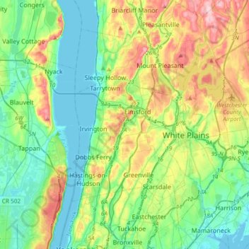
Nome: Mappa topografica Saw Mill River, altitudine, rilievo.
Altitudine media: 69 m
Altitudine minima: -2 m
Altitudine massima: 227 m
Fai una donazione
Equipaggiati per la tua prossima avventura:
In qualità di Affiliato Amazon, questo sito riceve una commissione sugli acquisti idonei, senza costi aggiuntivi per l’utente.