
Fai una donazione
Equipaggiati per la tua prossima avventura:
In qualità di Affiliato Amazon, questo sito riceve una commissione sugli acquisti idonei, senza costi aggiuntivi per l’utente.
Mappa topografica Bon Air
Clicca sulla mappa per visualizzare l'altitudine.
Fai una donazione
Equipaggiati per la tua prossima avventura:
In qualità di Affiliato Amazon, questo sito riceve una commissione sugli acquisti idonei, senza costi aggiuntivi per l’utente.
Bon Air
In the 19th century, it was believed that the higher elevation and distance from the urban area of Richmond provided a more healthful atmosphere, particularly in the hot summer months in central Virginia. With its nearby location and greater elevation, Bon Air offered these features nearby, and was founded as a summer resort town about 8 miles (13 km) outside of Richmond by railroad. One of the founders was Colonel Algernon S. Buford, of Chatham, Virginia, who is best known for his presidency of the Richmond and Danville Railroad during its massive postwar expansion, which ended in 1894 with the formation of the Southern Railway System (now part of Norfolk Southern). Bon Air's connections with the railroad's leaders could possibly be evidenced by the fact that over many of the years until passenger service ended in 1957, the community simultaneously had three stops within 1-mile (2 km) of trackage.
Fai una donazione
Equipaggiati per la tua prossima avventura:
In qualità di Affiliato Amazon, questo sito riceve una commissione sugli acquisti idonei, senza costi aggiuntivi per l’utente.
A proposito di questa mappa
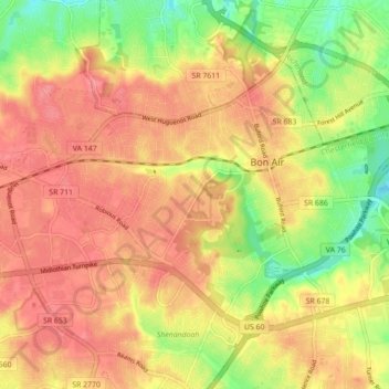
Nome: Mappa topografica Bon Air, altitudine, rilievo.
Luogo: Bon Air, Chesterfield County, Virginia, 23235, United States (37.49501 -77.61615 37.54314 -77.52818)
Altitudine media: 87 m
Altitudine minima: 40 m
Altitudine massima: 118 m
Fai una donazione
Equipaggiati per la tua prossima avventura:
In qualità di Affiliato Amazon, questo sito riceve una commissione sugli acquisti idonei, senza costi aggiuntivi per l’utente.