
Mappa topografica Maynooth
Clicca sulla mappa per visualizzare l'altitudine.
A proposito di questa mappa
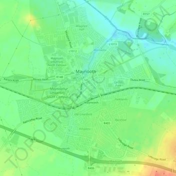
Nome: Mappa topografica Maynooth, altitudine, rilievo.
Luogo: Maynooth, County Kildare, Leinster, Ireland (53.36410 -6.61348 53.39590 -6.57075)
Altitudine media: 61 m
Altitudine minima: 44 m
Altitudine massima: 88 m
Altre mappe topografiche
Clicca su una mappa per visualizzarne la topografia, l'altitudine e il rilievo.
Leixlip
British publisher and cartographer Samuel Lewis mentions Confey Castle in the first volume of his 1837 work A Topographical Dictionary of Ireland. In it, he comments that Confey's (or Confoy as he spells it) population was 165, had formerly had a town and a castle of some importance, which were noticed by…
Altitudine media: 55 m
Leixlip
Ireland > County Kildare > Leixlip
British publisher and cartographer Samuel Lewis mentions Confey Castle in the first volume of his 1837 work A Topographical Dictionary of Ireland. In it, he comments that Confey's (or Confoy as he spells it) population was 165, had formerly had a town and a castle of some importance, which were noticed by…
Altitudine media: 53 m
Leixlip
British publisher and cartographer Samuel Lewis mentions Confey Castle in the first volume of his 1837 work A Topographical Dictionary of Ireland. In it, he comments that Confey's (or Confoy as he spells it) population was 165, had formerly had a town and a castle of some importance, which were noticed by…
Altitudine media: 55 m