
Fai una donazione
Equipaggiati per la tua prossima avventura:
In qualità di Affiliato Amazon, questo sito riceve una commissione sugli acquisti idonei, senza costi aggiuntivi per l’utente.
Mappa topografica Dal Lake
Clicca sulla mappa per visualizzare l'altitudine.
Fai una donazione
Equipaggiati per la tua prossima avventura:
In qualità di Affiliato Amazon, questo sito riceve una commissione sugli acquisti idonei, senza costi aggiuntivi per l’utente.
Dal Lake
The average elevation of the lake is 1,583 metres (5,194 ft). The depth of water varies from 6 metres (20 ft) at its deepest in Nigeen lake to 2.5 metres (8.2 ft), the shallowest at Gagribal. The depth ratio between the maximum and minimum depths varies with the season between 0.29 and 0.25, which is interpreted as flat bed slope. The length of the lake is 7.44 kilometres (4.62 mi) with a width of 3.5 kilometres (2.2 mi). The lake has a basin having shore length of 15.5 kilometres (9.6 mi) and roads run all along the periphery. Irreversible changes through urban developments have placed further restrictions on the flow of the lake and as a result, marshy lands have emerged on the peripheral zones, notably in the foothill areas of the Shankaracharya and Zaharbwan hills. These marshy lands have since been reclaimed and converted into large residential complexes.
Fai una donazione
Equipaggiati per la tua prossima avventura:
In qualità di Affiliato Amazon, questo sito riceve una commissione sugli acquisti idonei, senza costi aggiuntivi per l’utente.
A proposito di questa mappa
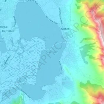
Nome: Mappa topografica Dal Lake, altitudine, rilievo.
Altitudine media: 1’715 m
Altitudine minima: 1’580 m
Altitudine massima: 2’716 m
Fai una donazione
Equipaggiati per la tua prossima avventura:
In qualità di Affiliato Amazon, questo sito riceve una commissione sugli acquisti idonei, senza costi aggiuntivi per l’utente.