
Mappa topografica Broomfield
Mappa interattiva
Clicca sulla mappa per visualizzare l'altitudine.
A proposito di questa mappa
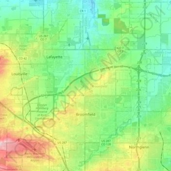
Nome: Mappa topografica Broomfield, altitudine, rilievo.
Luogo: Broomfield, Colorado, United States (39.88920 -105.16726 40.04423 -104.96093)
Altitudine media: 1’609 m
Altitudine minima: 1’532 m
Altitudine massima: 1’777 m
The elevation in Broomfield ranges from 5,096 to 5,856 feet. At the 2020 United States Census, Broomfield had a total area of 21,471 acres (86.890 km2) including 371 acres (1.503 km2) of water. It is the smallest county by area in Colorado and the 5th smallest in the United States. Broomfield is the second most densely populated county in Colorado behind Denver.