
Fai una donazione
Equipaggiati per la tua prossima avventura:
In qualità di Affiliato Amazon, questo sito riceve una commissione sugli acquisti idonei, senza costi aggiuntivi per l’utente.
Mappa topografica Brymbo
Clicca sulla mappa per visualizzare l'altitudine.
Fai una donazione
Equipaggiati per la tua prossima avventura:
In qualità di Affiliato Amazon, questo sito riceve una commissione sugli acquisti idonei, senza costi aggiuntivi per l’utente.
Brymbo
While there was mining of coal in the area on a small scale, the late eighteenth century saw an expansion in activity, particularly after the industrialist John "Iron-Mad" Wilkinson purchased Brymbo Hall and began developing its estate, mining coal and ironstone and building an ironworks which was later to become the Brymbo Steelworks. By 1821 there was a total of 41 coal pits on the Brymbo Hall estate alone. In the nineteenth century, a number of larger deep mines were sunk around the area, and the majority of the village of Brymbo was developed as accommodation for the miners and ironworkers. The village itself was constructed on and around the steep sides of Brymbo Hill with views towards the Cheshire Plain, though the area's topography was later to cause problems when the steelworks expanded in 1956: the new parts had to be built on a vast artificial plateau of slag from the furnaces, filling the width of the valley and burying most of the village of Lodge, whose houses were purchased and demolished.
Fai una donazione
Equipaggiati per la tua prossima avventura:
In qualità di Affiliato Amazon, questo sito riceve una commissione sugli acquisti idonei, senza costi aggiuntivi per l’utente.
A proposito di questa mappa
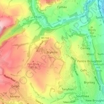
Nome: Mappa topografica Brymbo, altitudine, rilievo.
Luogo: Brymbo, Wrexham, Wales, LL11 5AS, United Kingdom (53.05664 -3.08078 53.09664 -3.04078)
Altitudine media: 195 m
Altitudine minima: 70 m
Altitudine massima: 337 m
Fai una donazione
Equipaggiati per la tua prossima avventura:
In qualità di Affiliato Amazon, questo sito riceve una commissione sugli acquisti idonei, senza costi aggiuntivi per l’utente.
Altre mappe topografiche
Clicca su una mappa per visualizzarne la topografia, l'altitudine e il rilievo.
Fai una donazione
Equipaggiati per la tua prossima avventura:
In qualità di Affiliato Amazon, questo sito riceve una commissione sugli acquisti idonei, senza costi aggiuntivi per l’utente.