
Mappa topografica Copley
Clicca sulla mappa per visualizzare l'altitudine.
A proposito di questa mappa
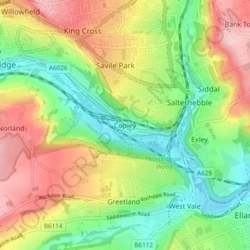
Nome: Mappa topografica Copley, altitudine, rilievo.
Altitudine media: 150 m
Altitudine minima: 65 m
Altitudine massima: 260 m
Altre mappe topografiche
Clicca su una mappa per visualizzarne la topografia, l'altitudine e il rilievo.
Todmorden
United Kingdom > England > Calderdale > Lydgate
Todmorden Town Hall, which was designed in the Neo-Classical style, dominates the centre of the town. The building straddles the Walsden Water, a tributary of the River Calder, and was situated in both Lancashire and Yorkshire until the administrative county boundary was moved on 1 January 1888. Designed by…
Altitudine media: 311 m
Calder & Hebble Navigation Halifax Cut
United Kingdom > England > Calderdale > Skircoat Green
Altitudine media: 136 m
Ragby Plantation
United Kingdom > England > Calderdale > Todmorden > Walsden > Bottoms
Altitudine media: 293 m
Gaddings Dam
United Kingdom > England > Calderdale > Todmorden > Walsden
Gaddings Dam is a locally owned reservoir near to Todmorden in West Yorkshire, England. The dam was built to power water mills in the Todmorden area, being superseded by steam power and left redundant. It is notable for having a sandy beach at the north-eastern side which attracts people to it during the…
Altitudine media: 283 m
Todmorden
United Kingdom > England > Calderdale
Todmorden Town Hall, which was designed in the Neo-Classical style, dominates the centre of the town. The building straddles the Walsden Water, a tributary of the River Calder, and was situated in both Lancashire and Yorkshire until the administrative county boundary was moved on 1 January 1888. Designed by…
Altitudine media: 311 m