
Mappa topografica Porterville
Mappa interattiva
Clicca sulla mappa per visualizzare l'altitudine.
Porterville
Porterville, lying along the foothills of the Sierras at an elevation of 455 feet (139 m), is located on State Highway 65, 165 miles (266 km) north of Los Angeles, and 171 miles (275 km) east of the Pacific Coast. The city has a strategic central location to major markets and a ready access to major transportation routes.
A proposito di questa mappa
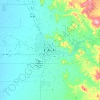
Nome: Mappa topografica Porterville, altitudine, rilievo.
Altitudine media: 222 m
Altitudine minima: 95 m
Altitudine massima: 1’003 m