
Fai una donazione
Equipaggiati per la tua prossima avventura:
In qualità di Affiliato Amazon, questo sito riceve una commissione sugli acquisti idonei, senza costi aggiuntivi per l’utente.
Mappa topografica Cumbernauld
Clicca sulla mappa per visualizzare l'altitudine.
Fai una donazione
Equipaggiati per la tua prossima avventura:
In qualità di Affiliato Amazon, questo sito riceve una commissione sugli acquisti idonei, senza costi aggiuntivi per l’utente.
Cumbernauld
Cumbernauld's name probably comes from the Gaelic comar nan allt, meaning "meeting of the burns or streams". There are differing views as to the etymology of this. One theory is that from its high point in the Central Belt, its streams flow both west to the River Clyde and east to the Firth of Forth so Cumbernauld's name is about it being on a watershed. Another theory ascribes the name to the meeting point of the Red Burn and Bog Stank streams within Cumbernauld Glen. 'Cumbernauld' is generally considered to be a Gaelic name. However, early forms containing Cumyr- hint at a Cumbric predecessor derived from *cömber, 'confluence' (c.f Welsh cymer, 'confluence'), synonymous with Aber. This seems to be suffixed with Cumbric *-ïn-alt, a topographical suffix perhaps referring to a hill or slope (Welsh yn allt, 'at a hill').
Fai una donazione
Equipaggiati per la tua prossima avventura:
In qualità di Affiliato Amazon, questo sito riceve una commissione sugli acquisti idonei, senza costi aggiuntivi per l’utente.
A proposito di questa mappa
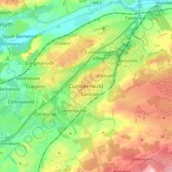
Nome: Mappa topografica Cumbernauld, altitudine, rilievo.
Altitudine media: 111 m
Altitudine minima: 37 m
Altitudine massima: 223 m
Fai una donazione
Equipaggiati per la tua prossima avventura:
In qualità di Affiliato Amazon, questo sito riceve una commissione sugli acquisti idonei, senza costi aggiuntivi per l’utente.