
Fai una donazione
Equipaggiati per la tua prossima avventura:
In qualità di Affiliato Amazon, questo sito riceve una commissione sugli acquisti idonei, senza costi aggiuntivi per l’utente.
Mappa topografica Blacksburg
Clicca sulla mappa per visualizzare l'altitudine.
Fai una donazione
Equipaggiati per la tua prossima avventura:
In qualità di Affiliato Amazon, questo sito riceve una commissione sugli acquisti idonei, senza costi aggiuntivi per l’utente.
Blacksburg
In the mid-1600s, English colonists were still uncertain of what lay beyond the Allegheny Mountains, whose topography and possession by native inhabitants, Tutelo-speaking tribes, were a barrier to expanded settlement by the Colony of Virginia. Abraham Wood, who commanded Fort Henry on the frontier (now the site of Petersburg, Virginia), and operated an Indian trading post nearby, organized several expeditions to explore farther west. A passage over the ridge was finally found in 1671 when explorers Batts and Fallam, sent by Wood, reached the present-day location of Blacksburg, Virginia. Their expedition followed Stroubles Creek, through the current locations of the town and campus of Virginia Tech, to what they named Wood's River.
Fai una donazione
Equipaggiati per la tua prossima avventura:
In qualità di Affiliato Amazon, questo sito riceve una commissione sugli acquisti idonei, senza costi aggiuntivi per l’utente.
A proposito di questa mappa
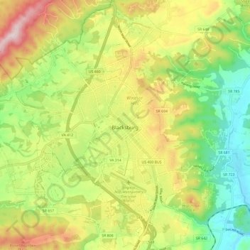
Nome: Mappa topografica Blacksburg, altitudine, rilievo.
Luogo: Blacksburg, Montgomery County, Virginia, United States (37.18389 -80.48068 37.27693 -80.37912)
Altitudine media: 621 m
Altitudine minima: 440 m
Altitudine massima: 860 m
Fai una donazione
Equipaggiati per la tua prossima avventura:
In qualità di Affiliato Amazon, questo sito riceve una commissione sugli acquisti idonei, senza costi aggiuntivi per l’utente.
Altre mappe topografiche
Clicca su una mappa per visualizzarne la topografia, l'altitudine e il rilievo.
Ramble Ridge
United States > Virginia > Montgomery County > Blacksburg > Ramble Ridge
Altitudine media: 632 m
Southgate
United States > Virginia > Montgomery County > Blacksburg > Southgate
Altitudine media: 643 m
Fai una donazione
Equipaggiati per la tua prossima avventura:
In qualità di Affiliato Amazon, questo sito riceve una commissione sugli acquisti idonei, senza costi aggiuntivi per l’utente.