
Fai una donazione
Equipaggiati per la tua prossima avventura:
In qualità di Affiliato Amazon, questo sito riceve una commissione sugli acquisti idonei, senza costi aggiuntivi per l’utente.
Mappa topografica Minneapolis
Clicca sulla mappa per visualizzare l'altitudine.
Fai una donazione
Equipaggiati per la tua prossima avventura:
In qualità di Affiliato Amazon, questo sito riceve una commissione sugli acquisti idonei, senza costi aggiuntivi per l’utente.
Minneapolis
Minneapolis is characterized by a diverse and dynamic topography. The city sits at an average elevation of approximately 830 feet (253 meters) above sea level, but this varies significantly across its landscape. The terrain is predominantly flat, interspersed with rolling hills, and is marked by the presence of numerous lakes, such as Lake Calhoun (Bde Maka Ska) and Lake Harriet, which contribute to the area's natural beauty. The lowest point in Minneapolis is around 665 feet (209 meters) near where Minnehaha Creek flows into the Mississippi River, while the highest elevations reach up to about 965 feet (294 meters) northeast of the city. This varied terrain is not only visually appealing but also supports a rich array of ecosystems and recreational opportunities, making Minneapolis a unique urban environment amidst natural landscapes.
Fai una donazione
Equipaggiati per la tua prossima avventura:
In qualità di Affiliato Amazon, questo sito riceve una commissione sugli acquisti idonei, senza costi aggiuntivi per l’utente.
A proposito di questa mappa
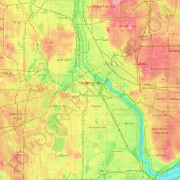
Nome: Mappa topografica Minneapolis, altitudine, rilievo.
Luogo: Minneapolis, Hennepin County, Minnesota, United States (44.89015 -93.32913 45.05125 -93.19386)
Altitudine media: 270 m
Altitudine minima: 211 m
Altitudine massima: 318 m
Fai una donazione
Equipaggiati per la tua prossima avventura:
In qualità di Affiliato Amazon, questo sito riceve una commissione sugli acquisti idonei, senza costi aggiuntivi per l’utente.
Altre mappe topografiche
Clicca su una mappa per visualizzarne la topografia, l'altitudine e il rilievo.
Pond-Dakota Mission Park
United States > Minnesota > Hennepin County > Bloomington
Altitudine media: 235 m
Elm Creek Park (Maple Grove Arboretum)
United States > Minnesota > Hennepin County > Maple Grove
Altitudine media: 278 m
Fai una donazione
Equipaggiati per la tua prossima avventura:
In qualità di Affiliato Amazon, questo sito riceve una commissione sugli acquisti idonei, senza costi aggiuntivi per l’utente.
Mississippi River
United States > Minnesota > Hennepin County > Minneapolis
The uppermost lock and dam on the Upper Mississippi River is the Upper St. Anthony Falls Lock and Dam in Minneapolis. Above the dam, the river's elevation is 799 feet (244 m). Below the dam, the river's elevation is 750 feet (230 m). This 49-foot (15 m) drop is the largest of all the Mississippi River locks…
Altitudine media: 256 m
Fai una donazione
Equipaggiati per la tua prossima avventura:
In qualità di Affiliato Amazon, questo sito riceve una commissione sugli acquisti idonei, senza costi aggiuntivi per l’utente.
Minnehaha Falls
United States > Minnesota > Hennepin County > Minneapolis
Fortunately for the generations to come, in 1883 the state legislature created the Minneapolis Board of Park Commissioners. The board began by acquiring park land near today's downtown Minneapolis. Their choice to hire noted landscape architect Horace Cleveland was fortunate. Cleveland was hired by the Board…
Altitudine media: 249 m
Fai una donazione
Equipaggiati per la tua prossima avventura:
In qualità di Affiliato Amazon, questo sito riceve una commissione sugli acquisti idonei, senza costi aggiuntivi per l’utente.
Wood Lake Nature Center
United States > Minnesota > Hennepin County > Richfield
Altitudine media: 260 m
Eden Prairie
United States > Minnesota > Hennepin County > Eden Prairie > Eden Prairie
Altitudine media: 267 m
Fai una donazione
Equipaggiati per la tua prossima avventura:
In qualità di Affiliato Amazon, questo sito riceve una commissione sugli acquisti idonei, senza costi aggiuntivi per l’utente.