

Mappa topografica Warangal
Clicca sulla mappa per visualizzare l'altitudine.
Warangal
Warangal is located at 18°00′N 79°35′E / 18.0°N 79.58°E / 18.0; 79.58. It has an average elevation of 266 metres (873 feet). It is settled in the eastern part of Deccan Plateau made up of granite rocks and hill formations which left the region barren making the cultivation dependent on seasonal rainfall. There are no major rivers flowing near the city, making it reliant on the Kakatiya Canal which originates from Sriram Sagar Project to meet the city's water requirements. Located in the semi-arid region of Telangana, Warangal has a predominantly hot and dry climate. Summer starts in March, and peak in May with average high temperatures in the 42 °C (108 °F) range. The monsoon arrives in June and lasts until September with about 550 mm (22 in) of precipitation. A dry, mild winter starts in October and lasts until early February, when there is little humidity and average temperatures in the 22–23 °C (72–73 °F) range. Many hill rocks and lakes are located around warangal. Padmakshi hill, mettu gutta, hanumathgiri gutta, ursu gutta and Govinda Rajula Gutta are famous hills with temples.
A proposito di questa mappa
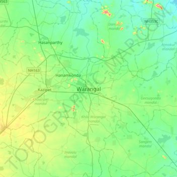
Nome: Mappa topografica Warangal, altitudine, rilievo.
Luogo: Warangal, Warangal mandal, Warangal, Telangana, 506002, India (17.82206 79.43710 18.14206 79.75710)
Altitudine media: 268 m
Altitudine minima: 212 m
Altitudine massima: 455 m