Geolocalizza

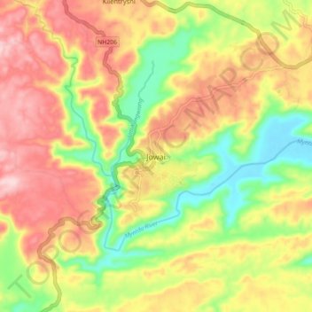
Mappa topografica Jowai

Clicca sulla mappa per visualizzare l'altitudine.

Jowai

Jowai (IPA: ʤəʊˈwaɪ) is the headquarters of the West Jaintia Hills district of the state of Meghalaya, India, and is home to the Pnar, a sub-tribe of the Khasi people. It is located on a plateau surrounded on three sides by the Myntdu river bordering Bangladesh to the south (about 50 km from the Indo-Bangladesh border). Due to its high altitude of 1365 m above sea level, Jowai experiences warm summers with cool to chilly winters.

Wikipedia (CC-BY-SA 3.0)

A proposito di questa mappa

Nome: Mappa topografica Jowai, altitudine, rilievo.

Luogo: Jowai, Thadlaskein, West Jaintia Hills, Meghalaya, 793150, India (25.40347 92.15732 25.48347 92.23732)

Altitudine media: 1’332 m

Altitudine minima: 1’211 m

Altitudine massima: 1’445 m

Equipaggiati per la tua prossima avventura:

⚡Power Bank - Batteria esterna per ricaricare dispositivi in cammino
🚲GPS per Bicicletta - Computer da bici con mappe topografiche e sentieri MTB
🚶Contapassi Professionale - Per chi vuole monitorare l'attività fisica quotidiana
📍GPS Portatile - Dispositivo GPS portatile per escursioni e geocaching
🔦Set Luci Bici LED - Illuminazione ad alta visibilità per tratti stradali e gallerie

In qualità di Affiliato Amazon, questo sito riceve una commissione sugli acquisti idonei, senza costi aggiuntivi per l’utente.