
Mappa topografica Tallahassee
Mappa interattiva
Clicca sulla mappa per visualizzare l'altitudine.
A proposito di questa mappa
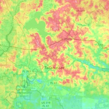
Nome: Mappa topografica Tallahassee, altitudine, rilievo.
Luogo: Tallahassee, Leon County, Florida, United States (30.34670 -84.37804 30.58724 -84.12995)
Altitudine media: 36 m
Altitudine minima: 2 m
Altitudine massima: 81 m
Tallahassee's terrain is hilly by Florida standards, being at the southern end of the Red Hills Region, just above the Cody Scarp. The elevation varies from near sea level to just over 200 feet (61 m), with the state capitol on one of the highest hills in the city. The city includes two large lake basins, Lake Jackson and Lake Lafayette, and borders the northern end of the Apalachicola National Forest.
Altre mappe topografiche
Clicca su una mappa per visualizzarne la topografia, l'altitudine e il rilievo.
Mitchell Island
United States > Florida > Leon County
Mitchell Island, Leon County, Florida, United States
Altitudine media: 52 m
Alfred B. Maclay Gardens State Park
United States > Florida > Leon County > Tallahassee
Alfred B. Maclay Gardens State Park, 3540, Thomasville Road, Tallahassee, Leon County, Florida, 32309, United States
Altitudine media: 58 m