
Mappa topografica Oakdale
Mappa interattiva
Clicca sulla mappa per visualizzare l'altitudine.
Oakdale
Historically the area has been used for orchards and other agricultural uses. Some of the common soil types found in Oakdale are Delhi sand, Oakdale sandy loam, Hanford sandy loam, and Tujunga loamy sand. Oakdale is generally on level ground at an elevation of approximately 190 feet (58 m) above mean sea level. Drainage is generally to the northwest towards the Stanislaus River.
A proposito di questa mappa
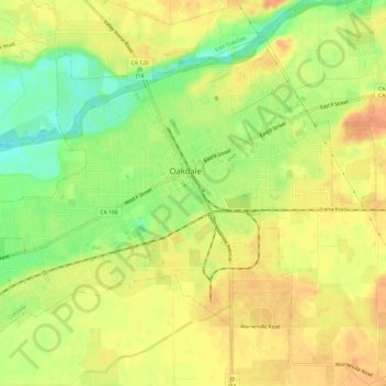
Nome: Mappa topografica Oakdale, altitudine, rilievo.
Altitudine media: 52 m
Altitudine minima: 26 m
Altitudine massima: 69 m
Altre mappe topografiche
Clicca su una mappa per visualizzarne la topografia, l'altitudine e il rilievo.
San Joaquin River National Wildlife Refuge
United States > California > Stanislaus County
Altitudine media: 14 m