
Fai una donazione
Equipaggiati per la tua prossima avventura:
In qualità di Affiliato Amazon, questo sito riceve una commissione sugli acquisti idonei, senza costi aggiuntivi per l’utente.
Mappa topografica Riverside
Clicca sulla mappa per visualizzare l'altitudine.
Fai una donazione
Equipaggiati per la tua prossima avventura:
In qualità di Affiliato Amazon, questo sito riceve una commissione sugli acquisti idonei, senza costi aggiuntivi per l’utente.
Riverside
Riverside is the 59th largest city in the United States, the 12th largest city in California, and the largest city in California's Inland Empire metro area. According to the United States Census Bureau, the city has a total area of 81.4 square miles (210.8 km2), of which 81.1 square miles (210 km2) is land and 0.3 square miles (0.78 km2) (0.37%) is water. The elevation of downtown Riverside is 860 feet (260 m). Hills within the city limits include Mount Rubidoux, a city landmark and tourist attraction. Riverside is surrounded by small and large mountains, some of which get a dusting of winter snow. Many residents also enjoy the many beaches of Southern California. Riverside is about a 47-mile drive to the Pacific Ocean and is close to Orange County and Los Angeles County.
Fai una donazione
Equipaggiati per la tua prossima avventura:
In qualità di Affiliato Amazon, questo sito riceve una commissione sugli acquisti idonei, senza costi aggiuntivi per l’utente.
A proposito di questa mappa
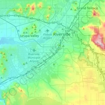
Nome: Mappa topografica Riverside, altitudine, rilievo.
Altitudine media: 351 m
Altitudine minima: 191 m
Altitudine massima: 932 m
Fai una donazione
Equipaggiati per la tua prossima avventura:
In qualità di Affiliato Amazon, questo sito riceve una commissione sugli acquisti idonei, senza costi aggiuntivi per l’utente.