
Fai una donazione
Equipaggiati per la tua prossima avventura:
In qualità di Affiliato Amazon, questo sito riceve una commissione sugli acquisti idonei, senza costi aggiuntivi per l’utente.
Mappa topografica Bridgewater
Clicca sulla mappa per visualizzare l'altitudine.
Fai una donazione
Equipaggiati per la tua prossima avventura:
In qualità di Affiliato Amazon, questo sito riceve una commissione sugli acquisti idonei, senza costi aggiuntivi per l’utente.
Bridgewater
According to the United States Census Bureau, the town has a total area of 2.52 sq mi (6.5 km2), nearly all of it being land. Most of the town is located within a bend of the North River. Floods have wrecked the town occasionally. The northern areas are partly shielded from flooding with an Army Corps of Engineers dam. The wooded monadnock called Round Hill (elevation approx. 1750 feet) dominates the town's western skyline.
Fai una donazione
Equipaggiati per la tua prossima avventura:
In qualità di Affiliato Amazon, questo sito riceve una commissione sugli acquisti idonei, senza costi aggiuntivi per l’utente.
A proposito di questa mappa
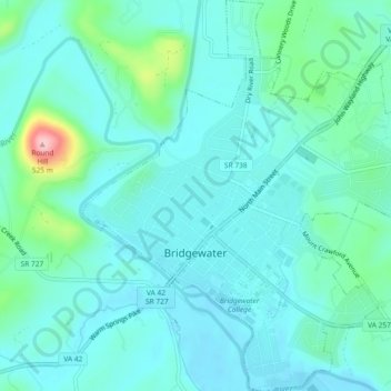
Nome: Mappa topografica Bridgewater, altitudine, rilievo.
Luogo: Bridgewater, Rockingham County, Virginia, United States (38.36928 -78.98997 38.40543 -78.94621)
Altitudine media: 380 m
Altitudine minima: 351 m
Altitudine massima: 515 m
Fai una donazione
Equipaggiati per la tua prossima avventura:
In qualità di Affiliato Amazon, questo sito riceve una commissione sugli acquisti idonei, senza costi aggiuntivi per l’utente.
Altre mappe topografiche
Clicca su una mappa per visualizzarne la topografia, l'altitudine e il rilievo.
Harrisonburg/Warm Springs Turnpike Park
United States > Virginia > Rockingham County > Bridgewater
Altitudine media: 378 m
Fai una donazione
Equipaggiati per la tua prossima avventura:
In qualità di Affiliato Amazon, questo sito riceve una commissione sugli acquisti idonei, senza costi aggiuntivi per l’utente.
Fai una donazione
Equipaggiati per la tua prossima avventura:
In qualità di Affiliato Amazon, questo sito riceve una commissione sugli acquisti idonei, senza costi aggiuntivi per l’utente.
Fai una donazione
Equipaggiati per la tua prossima avventura:
In qualità di Affiliato Amazon, questo sito riceve una commissione sugli acquisti idonei, senza costi aggiuntivi per l’utente.